
Trip from Janesville, CA to Long Beach, CA

Last recalculated Apr 16, 2026

Drive Time

11h 23m

Distance

566.8 mi

912 km

Drive Score

9/10

Great drive

Same Day?

2-day trip

Fuel Cost

$130

one way

EV Charging

Unknown

Best Time to Leave

Save up to 30 min
4 AM
11h 14m ★
6 AM
11h 24m
8 AM
11h 44m
10 AM
11h 31m
12 PM
11h 29m
3 PM
11h 32m
5 PM
11h 43m
8 PM
11h 18m

Estimated drive times based on typical traffic patterns. Actual times may vary with weather, construction, and real-time conditions.

Downtown Janesville, CA, CA

Janesville, CA

Stephen Leonardi

city in Los Angeles County, California, United States

Long Beach, CA

Wikimedia Commons

Trip Overview

The drive from Janesville, CA to Long Beach, CA covers 566.8 miles and takes about 11h 23m behind the wheel. It usually feels better as a 2-day road trip than as one long push.

The route leans on US 395, Grand Army of the Republic Highway, Route 395 for much of the mileage, and the overall profile is long-distance drive. The longest uninterrupted segment is about 109.1 miles on US 395. At current regular gas prices, budget about $130.27 one way before food or hotel costs.

Trip Pace

Best split across 2 days

Treat the return leg as its own travel day rather than an afterthought.

Break Rhythm

3 planned breaks

Plan on a short reset every 3 to 4 hours to stay fresh behind the wheel.

Midpoint

283.4 miles from Janesville, CA

A natural place for your longest stop of the day , about 5h 51m into the drive .

Who Is This Route For?

Solo Traveler

11h 23m drive, plan rest stops for pacing.

Scenic Drive

Long-distance drive route profile with national parks nearby.

Drive Character

At 566.8 miles and 11h 23m of driving, this is a route where fuel stops, weather, and timing matter more than any single turn. The main roads are US 395 and Grand Army of the Republic Highway.

Expect a mix of faster highway mileage and slower local approaches near the beginning or end.
There are about 48 navigation steps in the underlying route data, so the final approach matters more than the middle miles.
US 395 is the longest continuous segment at about 109.1 miles.

How Hard Is This Drive?

At 11h 23m, this is a long-haul route where pacing matters more than any single turn. This route has several spots where lane changes, forks, or exits need your full attention. The trickiest moment comes around 120.6 miles in near US 395.

Driving Effort 9/10

High effort - long or complex enough to need steady focus all day

Balances navigation complexity with total wheel time.

This is a demanding drive. With 26 significant decision points across 566.8 miles, you will need to stay alert - especially through interchange areas and urban stretches. Consider splitting it into segments if you are not comfortable with fast highway navigation.

Where does it get tricky?

The main spots that need attention: at 120.6 miles (US 395): Lane positioning matters here; at 186.7 miles (US 395 / Main Street): Lane positioning matters here; at 398.8 miles (CA 14; US 6 Hist / Aerospace Highway): Highway fork - watch signs carefully. Lane positioning matters here.

Critical Maneuvers

5 of 26 key points

These are the spots where you need to pay the most attention. Preview them before you drive.

7
120.6 mi into trip | ~2h 21m in | US 395

At end of road, turn right onto US 395

Lane positioning matters here

Use the left lane.
6
186.7 mi into trip | ~3h 53m in | US 395 / Main Street

Turn left onto US 395 / Main Street

Lane positioning matters here

Use the straight lane.
6
398.8 mi into trip | ~8h 9m in | CA 14; US 6 Hist / Aerospace Highway

Keep slight right at fork onto CA 14; US 6 Hist / Aerospace Highway

Highway fork - watch signs carefully. Lane positioning matters here

Use the slight left / slight right lanes.
8
519.9 mi into trip | ~10h 26m in | I 5 Truck

Keep slight right at fork onto I 5 Truck toward I 405 South

Highway fork - watch signs carefully. Lane positioning matters here

Use the straight / slight right lanes. Exit 158 Toward I 405 South
7
564.4 mi into trip | ~11h 18m in

Take the exit toward Downtown Long Beach, Convention Center, Aquarium

Exit ramp - move to the correct lane early. Lane positioning matters here. Multiple destination signs - pick the right one

Use the slight left / straight lanes. Toward Downtown Long Beach, Convention Center,...

Main Roads

Road Distance Duration
US 395 109.1 mi 2h 21m
Grand Army of the Republic Highway 104.6 mi 2h 2m
Route 395 56.2 mi 1h 4m
Martin Luther King Junior Memorial Highway 50.9 mi 57m
Antelope Valley Freeway 49.1 mi 54m
Main Street 44.5 mi 54m
Aerospace Highway 42.1 mi 47m
I 405 Truck 23 mi 26m
Longest stretch: US 395 — 109.1 mi, about 2h 21m

Turn-by-Turn Driving Directions

Step-by-step road directions between Janesville, CA and Long Beach, CA.

1

Start on Main Street

0.7 mi · 1 min · Main Street
2

Turn left onto Sears Road

0.2 mi · 32 sec · Sears Road
3

Turn right onto US 395

56 mi · 1 hr 4 min · Route 395
4

Continue on US 395

51 mi · 57 min · Martin Luther King Junior Memorial Highway
5

Turn left onto US 395

11 mi · 14 min · South Carson Street
Use the left lane.
6

Take the exit

488 ft · 13 sec
7

Turn straight onto NV 88

0.3 mi · 42 sec · Woodfords Road
8

Enter roundabout onto County Road

144 ft · 2 sec · County Road
9

Continue on County Road

1.1 mi · 2 min · County Road
10

At end of road, turn right onto US 395

66 mi · 1 hr 30 min · US 395
Use the left lane.
11

Turn left onto Emigrant Street

0.5 mi · 42 sec · Emigrant Street
12

At end of road, turn right onto Sinclair Street

0.1 mi · 13 sec · Sinclair Street
13

Turn left onto US 395

44 mi · 53 min · Main Street
Use the straight lane.
14

Continue on US 395

44 mi · 50 min · US 395
Use the straight lane.
15

Turn right onto North Barlow Lane

1.0 mi · 1 min · North Barlow Lane
16

Turn left onto CA 168

1.5 mi · 2 min · West Line Street
17

Turn right onto US 395; CA 168; US 6 Hist

2.4 mi · 3 min · South Main Street
18

Continue on US 395; CA 168; US 6 Hist

5.0 mi · 5 min · El Camino Sierra
Use the straight / slight right lanes.
19

Continue on US 395; CA 168; US 6 Hist

7.4 mi · 8 min · Grand Army of the Republic Highway
Use the straight lane.
20

Continue on US 395; US 6 Hist

0.2 mi · 32 sec · North Main Street
21

Continue on US 395; US 6 Hist

26 mi · 31 min · Grand Army of the Republic Highway
Use the straight lane.
22

Continue on US 395; US 6 Hist

0.7 mi · 1 min · North Edwards Street
23

Continue on US 395; US 6 Hist

15 mi · 17 min · Grand Army of the Republic Highway
Use the straight lane.
24

Continue on US 395; US 6 Hist

2.2 mi · 4 min · North Main Street
25

Continue on US 395; US 6 Hist

56 mi · 1 hr 4 min · Grand Army of the Republic Highway
Use the straight lane.
26

Continue on US 395; US 6 Hist

7.0 mi · 8 min · Blue Star Memorial Highway
Use the straight lane.
27

Keep slight right at fork onto CA 14; US 6 Hist

6.4 mi · 7 min · Aerospace Highway
Use the slight left / slight right lanes.
28

Continue on CA 14; CA 178; US 6 Hist

22 mi · 25 min · Midland Trail
29

Continue on CA 14; US 6 Hist

20 mi · 23 min · Aerospace Highway
Use the straight / slight right lanes.
30

At end of road, turn left onto CA 14; CA 58 BUS; US 6 Hist

4.7 mi · 6 min · Sierra Highway
Use the left lane.
31

Continue on CA 14

16 mi · 16 min · Aerospace Highway
Use the straight / slight right lanes.
32

Continue on CA 14; CA 138

48 mi · 53 min · Antelope Valley Freeway
Use the straight / slight right lanes.
33

Keep slight left at fork onto CA 14

1.0 mi · 1 min · Antelope Valley Freeway
Use the straight / slight right lanes.
34

Keep slight left at fork

0.5 mi · 36 sec
Use the straight / slight right lanes.
35

Merge onto I 5

2.6 mi · 3 min · Golden State Freeway
Use the straight / slight right lanes.
36

Keep slight right at fork onto I 5 Truck

0.3 mi · 17 sec · I 5 Truck
Exit 158 Toward I 405 South Use the straight / slight right lanes.
37

Keep slight right at fork onto I 405 Truck

23 mi · 26 min · I 405 Truck
Use the straight / slight right lanes.
38

Keep slight right at fork onto I 405

18 mi · 20 min · San Diego Freeway
Use the straight / slight right lanes.
39

Take the exit

377 ft · 9 sec
Toward I 710 South: Long Beach Use the slight right lane.
40

Continue on this road

0.3 mi · 39 sec · this road
Exit 32B Toward I 710 South: Long Beach
41

Merge onto I 710

2.4 mi · 3 min · Long Beach Freeway
Use the straight / slight right lanes.
42

Continue on I 710

0.5 mi · 40 sec · Seaside Freeway
Use the straight / slight right lanes.
43

Take the exit

0.3 mi · 37 sec
Toward Downtown Long Beach, Convention Center, Aquarium Use the slight left / straight lanes.
44

Continue on Shoreline Drive

1.3 mi · 2 min · Shoreline Drive
45

Turn left onto South Chestnut Place

0.2 mi · 30 sec · South Chestnut Place
Use the left / uturn lanes.
46

Turn right onto West Ocean Boulevard

0.5 mi · 1 min · West Ocean Boulevard
47

Continue on East Ocean Boulevard

0.1 mi · 21 sec · East Ocean Boulevard
Use the left lane.
48

Arrive at destination

East Ocean Boulevard

Trip Plan

Morning Departure

Start early — leave by 6-7 AM to arrive at a reasonable hour.

Evening Departure

This is a long drive — plan for a morning departure or consider splitting it into two days.

This drive is better paced as a 2-day trip.
Plan roughly 3 meaningful breaks for fuel, food, and rest.
The halfway point lands around 283.4 miles from Janesville, CA, or about 5h 51m into the drive.
The longest continuous stretch on this route runs about 109.1 miles.

Consider an overnight stop or starting very early.

Departure

Before you leave

Start with fuel, water, and navigation already sorted so the first hour feels easy.

First stop

Around 125 miles or 2h 28m in

Use this first pause for coffee, a restroom break, and a quick traffic check ahead.

Halfway reset

Around 283.4 miles or 5h 51m in

This is the best place for your longest stop, a real meal, and a full fuel check.

Overnight split

Day 1 wrap after about 283.4 miles or 5h 51m

Stop before fatigue turns the last few hours into a grind. You want day two to start fresh, not just resumed.

Final approach

Final hour starts around 10h 11m

Traffic, exits, and arrival timing usually matter more near Long Beach, CA than in the middle of the route.

Before You Leave

+

Open the route before leaving Janesville, CA so your first major turns are already loaded.

+

Leave with enough water and a charging cable within reach, not packed away.

+

Check your fuel range against the first long segment, especially if you are starting outside city service areas.

+

Pick one backup stop option before the midpoint in case traffic changes your pacing.

+

Treat this as a 2-day road trip and book the overnight stop before the busiest arrival window.

Day 1

Settle into the route from Janesville, CA

Aim for roughly 283 miles and 5.7 hours of wheel time on this day.

Day 2

Finish the approach into Long Beach, CA

Aim for roughly 283 miles and 5.7 hours of wheel time on this day.

Your first comfortable stop window is around 125 miles from Janesville, CA.
This route usually feels better as a 2-day drive than as one long push.
Plan about 3 real breaks rather than only quick fuel stops.
The longest stretch is on US 395 for about 109.1 miles.

Where to Stop

Rest stops, refuel points, and overnight suggestions along this route.

Halfway Point

Midpoint

About 283.4 mi from Janesville, CA · 5h 51m into the drive

city in El Dorado County, California, United States

First major stop

Coffee and fuel

South Lake Tahoe, CA

187 mi into the route

Best for: Coffee, fuel, and an easy first stretch

This is a natural early stop once the first hours of the drive are behind you.

city and county seat of Kern County, California, United States

Second major stop

Overnight candidate

Bakersfield, CA

374 mi into the route

Best for: Hotel check-in, dinner, and a fresh start

This lines up well with a realistic day-end stop if you are breaking the drive into stages.

Find hotels in Bakersfield, CA

Popular next leg

Bakersfield, CA to Long Beach, CA

136 mi · 2h 39m

Overnight Options

Night 1

South Lake Tahoe, CA

283 mi · about 5.7h in

A practical overnight split lands near South Lake Tahoe, CA after about 283 miles or 5.7 hours of driving.

Find hotels

Pacing Suggestions

South Lake Tahoe, CA

Fuel and coffee

A short stop after about 126 miles helps settle the day before fatigue starts building.

South Lake Tahoe, CA

Meal break

The midpoint is around 285.3 miles from Janesville, CA, which is a good place for a longer meal and fuel stop.

Overnight split

Hotel stop

For a steadier pace, wrap day one after about 285 miles or 4.9 hours on the road.

Arriving in Long Beach, CA

The final approach into Long Beach, CA usually feels slower than the middle of the drive, so avoid planning your tightest schedule at the very end.

Try to arrive with enough fuel left to skip an immediate station stop unless you already know the area around Long Beach, CA.

On a multi-day trip, keep the last day a little lighter so you reach Long Beach, CA with some flexibility left in the schedule.

After long uninterrupted mileage, take five minutes before the last urban segment to reset and refocus on exits, merges, and city traffic.

These stop ideas are pacing suggestions — the exact town or exit can change with traffic, hotel plans, and fuel range.

National Parks Near This Route

Worth a detour if your schedule allows.

Devils Postpile National Monument

Devils Postpile National Monument

National Monument

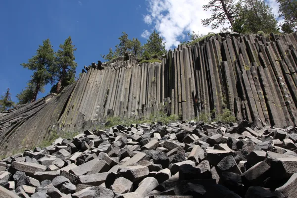
Established in 1911 by presidential proclamation, Devils Postpile National Monument protects and preserves the Devils Postpile formation, the 101-foot high Rainbow Falls, and pristine mountain scenery...

9 mi from route ~23 min detour Free near mile 236.1
View on nps.gov
Santa Monica Mountains National Recreation Area

Santa Monica Mountains National Recreation Area

National Recreation Area

The Santa Monica Mountains offer easy access to surprisingly wild places. Experience the famous beaches of Malibu or explore more than 500 miles of trails. The park abounds with historical and cultura...

18 mi from route ~45 min detour Free near mile 531.2
View on nps.gov
César E. Chávez National Monument

César E. Chávez National Monument

National Monument

Yes, we can! Widely recognized as the most important Latino leader in the United States during the twentieth century, Cesar Chavez led farm workers and supporters in the establishment of the country's...

26 mi from route ~65 min detour Free near mile 452.5
View on nps.gov
Yosemite National Park

Yosemite National Park

National Park

Not just a great valley, but a shrine to human foresight, the strength of granite, the power of glaciers, the persistence of life, and the tranquility of the High Sierra. First protected in 1864, Yose...

26 mi from route ~64 min detour $35 near mile 216.4
View on nps.gov

Park data from the National Park Service API. Alerts update every 2 hours.

Fuel & Cost

Regular Gas

$130.27 one way

$260.55 round trip

$5.84/gal 25.4 MPG avg 198 kg CO2
Fuel Type $/gal One Way Round Trip
midgrade $6.02 $134.25 $268.49
premium $6.18 $137.84 $275.68
diesel $5.61 $125.14 $250.28

No toll roads detected on this route.

Estimated Trip Cost (one way, 1 person)

Fuel

$130

Hotel (1n)

$80–$140

Meals

$50–$100

Total

$260–$370

Rough estimate based on US averages. Hotel $80–$140/night, meals $25–$50/day.

Estimated CO2 emission: 198.3 kg one way. Prices: EIA weekly data, 2026-04-13.

Driving Electric?

About $60 in charging · 2 stops · 67% less CO2

Vehicle Type kWh Stops DC Fast Home Charge
Average EV 170 2 $59.51 $27.21
Efficient EV 141.7 1 $49.59 $22.67
EV Truck/SUV 226.7 2 $79.35 $36.28

Gas CO2

198 kg

EV CO2

66 kg (67% less)

Plan for 2 charging stops, roughly every 270 miles. Allow 25-40 minutes per stop at a DC fast charger.

DC fast charging avg $0.35/kWh. Home charging avg $0.16/kWh. US grid CO2: 0.39 kg/kWh.

Travel Intel

Current conditions at both ends of the drive.

Forecast as of Apr 13, 2026

Origin

Janesville, CA

Morning in Janesville on Thursday

Local time

11:50 AM

PDT

Current temp

35°F

Unavailable

Live forecast

Destination

Long Beach, CA

Morning in Long Beach on Thursday

Local time

11:50 AM

PDT

Current temp

56°F

Unavailable

Live forecast

Seasonal Notes

Summer travel usually means heavier construction, hotter rest stops, and busier weekend traffic around major cities.

Winter travel shortens daylight, so a route that looks manageable on paper can feel much longer after dark.

Holiday weekends tend to make both departure and arrival windows slower than the raw route time suggests.

For long drives, weather on day two can matter just as much as conditions at departure, so check the whole travel window rather than only the first day.

Time zone

Same local time

Origin and destination are on the same clock, so arrival timing is easier to judge at a glance.

Temperature spread

21 degrees warmer at arrival

A meaningful temperature swing is a good cue to rethink layers, water, and how soon you want to arrive.

Road read

11h 23m on the road

This is long enough that the arrival forecast matters almost as much as departure conditions. Recheck both ends before you roll.

Weather data from the National Weather Service. Conditions may change; check closer to your travel date.

Frequently Asked Questions

The drive from Janesville, CA to Long Beach, CA covers 566.8 miles and takes about 11h 23m without stops. Add 15-30 minutes for a fuel or rest stop on longer drives.
The main roads are US 395, Grand Army of the Republic Highway, Route 395. Expect a mix of highway and local road driving.
Consider an overnight stop or starting very early.
Yes. This route is usually more comfortable as a 2-day drive. A sensible stopping point is after roughly 283 miles on day one.
The midpoint is about 283.4 miles from Janesville, CA. Look for rest areas, gas stations, or food options near the halfway mark.
At current regular gas prices, expect to spend about $130.27 one way. This estimate uses 25.4 MPG — your actual cost will vary with your vehicle's fuel efficiency and current gas prices.
Start early — leave by 6-7 AM to arrive at a reasonable hour. This is a long drive — plan for a morning departure or consider splitting it into two days.
Plan about 3 meaningful breaks for fuel, food, or rest. Plan on a short reset every 3 to 4 hours to stay fresh behind the wheel.
This is a demanding drive. With 26 significant decision points across 566.8 miles, you will need to stay alert - especially through interchange areas and urban stretches. Consider splitting it into segments if you are not comfortable with fast highway navigation.
The main spots that need attention: at 120.6 miles (US 395): Lane positioning matters here; at 186.7 miles (US 395 / Main Street): Lane positioning matters here; at 398.8 miles (CA 14; US 6 Hist / Aerospace Highway): Highway fork - watch signs carefully. Lane positioning matters here.
The route from Janesville, CA to Long Beach, CA does not surface many named destination signs beyond the main corridor.

Was this helpful?

Thanks for your feedback!

Your tip has been submitted. Thanks!

/500

Explore More

Return Trip

Long Beach, CA to Janesville, CA

Plan the drive back the other way.

566.4 mi 11h 25m

Explore more options from Janesville, CA or browse trips ending in Long Beach, CA.

Looking for more statewide routes? Browse CA road trips.

Explore maps for Janesville, CA or Long Beach, CA on MapSof.net.