
Trip from North Las Vegas, NV to Gardnerville, NV

Last recalculated Apr 16, 2026

Drive Time

8h 21m

Distance

414 mi

666 km

Drive Score

7/10

Good drive

Same Day?

2-day trip

Fuel Cost

$82

one way

EV Charging

Unknown

Best Time to Leave

Save up to 22 min
4 AM
8h 14m ★
6 AM
8h 21m
8 AM
8h 36m
10 AM
8h 26m
12 PM
8h 25m
3 PM
8h 27m
5 PM
8h 36m
8 PM
8h 17m

Estimated drive times based on typical traffic patterns. Actual times may vary with weather, construction, and real-time conditions.

city in Clark County, Nevada, United States

North Las Vegas, NV

Wikimedia Commons

census-designated place in Douglas County, Nevada, United States

Gardnerville, NV

Wikimedia Commons

Trip Overview

This 414-mile journey from North Las Vegas, NV, to Gardnerville, NV, is estimated to take about 8 hours and 21 minutes of driving time, making it a comfortable two-day trip. With a fuel cost around $82, this route primarily uses Veterans Memorial Highway and US 95 ALT, featuring a relatively low 10% highway share. Expect a turn-heavy local drive experience across the Mountain West region. Given the duration and road profile, splitting this drive over two days is highly recommended to enjoy the journey without feeling rushed. Planning for two stops along the way will break up the drive nicely.

Trip Pace

Best split across 2 days

Treat the return leg as its own travel day rather than an afterthought.

Break Rhythm

2 planned breaks

Plan on a short reset every 3 to 4 hours to stay fresh behind the wheel.

Midpoint

207 miles from North Las Vegas, NV

A natural place for your longest stop of the day , about 4h 3m into the drive .

Who Is This Route For?

Family Friendly

Moderate complexity with 2 natural rest stops along the way.

Solo Traveler

8h 21m drive, plan rest stops for pacing.

Scenic Drive

Turn-heavy local drive route profile with national parks nearby.

Drive Character

The character of this drive is best described as a turn-heavy local road experience, with only 10% of the route on highways. You'll be spending most of your time navigating through local roads, including sections of Veterans Memorial Highway and Silver Peak Road. The longest uninterrupted stretch you'll encounter is 262.3 miles on Veterans Memorial Highway, so be prepared for varying road conditions and speeds as you move between different types of terrain. This isn't a high-speed interstate cruise; rather, it's a more intimate exploration of the Nevada landscape.

This route has more turning and local-road decision points than a simple highway run.
There are about 40 navigation steps in the underlying route data, so the final approach matters more than the middle miles.
Veterans Memorial Highway is the longest continuous segment at about 262.3 miles.

How Hard Is This Drive?

Expect a hands-on drive with frequent turns and local roads rather than long highway stretches. You will hit about 21 points where you need to pay attention to lane position or signs. The trickiest moment comes early in the drive near Constitution Way.

Driving Effort 6/10

Moderate - straightforward overall, but long enough or busy enough to require pacing

Balances navigation complexity with total wheel time.

This drive requires moderate attention. Across 414 miles you will encounter 21 spots where lane choice or exit timing matters. Not difficult for experienced highway drivers, but worth previewing the tricky sections before you go.

Where does it get tricky?

The main spots that need attention: near the start (Constitution Way): Complex interchange - multiple decisions in a short stretch; at 0.7 miles (East Carey Avenue): Roundabout - know your exit number before entering; at 2.3 miles (NV 574 / East Cheyenne Avenue): Lane positioning matters here.

Critical Maneuvers

5 of 21 key points

These are the spots where you need to pay the most attention. Preview them before you drive.

6
0 mi into trip | ~0m in | Constitution Way

At end of road, turn right onto Constitution Way

Complex interchange - multiple decisions in a short stretch

6
0.7 mi into trip | ~1m in | East Carey Avenue

Enter roundabout onto East Carey Avenue

Roundabout - know your exit number before entering

4
2.3 mi into trip | ~4m in | NV 574 / East Cheyenne Avenue

Turn left onto NV 574 / East Cheyenne Avenue

Lane positioning matters here

Use the left lane.
6
9.3 mi into trip | ~16m in

Take the ramp toward I 11 North, US 95 North: Tonopah, Reno

Lane positioning matters here. Multiple destination signs - pick the right one

Use the right lane. Toward I 11 North, US 95 North: Tonopah, Reno
5
9.7 mi into trip | ~16m in | I 11; US 95 / Purple Heart Highway

Merge onto I 11; US 95 / Purple Heart Highway

Merge point - match speed before joining. Lane positioning matters here

Use the straight / slight right lanes.

Main Roads

Road Distance Duration
Veterans Memorial Highway 262.3 mi 4h 50m
Silver Peak Road 45.6 mi 57m
US 95 ALT 23.3 mi 25m
Main Street 16.5 mi 22m
NV 208 14.8 mi 22m
Nordyke Road 11.4 mi 15m
Topaz Road 9.3 mi 13m
Purple Heart Highway 7 mi 8m
Longest stretch: Veterans Memorial Highway — 262.3 mi, about 4h 50m

Turn-by-Turn Driving Directions

Step-by-step road directions between North Las Vegas, NV and Gardnerville, NV.

1

Start on this road

261 ft · 21 sec · this road
2

At end of road, turn right onto Constitution Way

0.1 mi · 31 sec · Constitution Way
3

Turn right onto Civic Center Drive

0.5 mi · 45 sec · Civic Center Drive
4

Turn left onto East Carey Avenue

0.1 mi · 19 sec · East Carey Avenue
5

Enter roundabout onto East Carey Avenue

82 ft · 1 sec · East Carey Avenue
6

Continue on East Carey Avenue

0.5 mi · 59 sec · East Carey Avenue
7

Turn right onto 5th Street

1.0 mi · 1 min · 5th Street
8

Turn left onto NV 574

4.4 mi · 6 min · East Cheyenne Avenue
Use the left lane.
9

Turn right onto NV 599

1.9 mi · 3 min · North Rancho Drive
10

Turn left onto NV 573

0.7 mi · 1 min · West Craig Road
11

Take the ramp

0.4 mi · 30 sec
Toward I 11 North, US 95 North: Tonopah, Reno Use the right lane.
12

Merge onto I 11; US 95

7.0 mi · 8 min · Purple Heart Highway
Use the straight / slight right lanes.
13

Continue on US 95

99 mi · 1 hr 48 min · Veterans Memorial Highway
Use the straight / slight right lanes.
14

Continue on US 95

0.2 mi · 46 sec · South 2nd Street
15

Turn right onto US 95

6.2 mi · 8 min · West Main Street
16

Continue on US 95

60 mi · 1 hr 4 min · Veterans Memorial Highway
17

Continue on US 95

0.4 mi · 1 min · South Sundog Avenue
18

Continue on US 95

0.5 mi · 1 min · East Crook Avenue
19

Continue on US 95

4.4 mi · 5 min · Veterans Memorial Highway
20

Turn left onto 3457

25 mi · 35 min · Silver Peak Road
21

Turn right onto Cinnabar Way

0.1 mi · 28 sec · Cinnabar Way
22

Turn slight right onto Silver Peak Road

21 mi · 22 min · Silver Peak Road
23

At end of road, turn left onto US 6; US 95

35 mi · 37 min · Veterans Memorial Highway
24

Continue on US 95

1.2 mi · 3 min · Front Street
25

Continue on US 95

7.8 mi · 8 min · Veterans Memorial Highway
26

Continue on US 95

0.9 mi · 2 min · Plymire Street
27

Continue on US 95

23 mi · 25 min · Veterans Memorial Highway
28

Take the exit onto US 95 Truck

1.3 mi · 2 min · US 95 Truck
29

Take the exit onto US 95 Truck

324 ft · 12 sec · US 95 Truck
30

Merge onto US 95

33 mi · 39 min · Veterans Memorial Highway
31

Turn left onto US 95 ALT

23 mi · 25 min · US 95 ALT
32

Turn right onto US 95 ALT

1.0 mi · 2 min · Goldfield Avenue
33

Turn left onto NV 339

11 mi · 15 min · Nordyke Road
34

Continue on NV 208; NV 339

9.3 mi · 13 min · Topaz Road
35

Keep slight right at fork onto NV 208

3.6 mi · 5 min · NV 208
36

Keep slight right at fork onto NV 208

11 mi · 16 min · NV 208
37

Turn right onto US 395

16 mi · 22 min · Main Street
38

Continue on US 395

2.0 mi · 4 min · US 395
39

Turn left onto NV 756

68 ft · 1 sec · Gilman Avenue
40

Arrive at destination

NV 756

Trip Plan

To make the most of this 414-mile drive, consider starting your journey early in the morning to maximize daylight hours, especially since it's a two-day trip. With two planned stops, you can easily break up the roughly 8-hour driving time into manageable segments, perhaps aiming for around 4 hours of driving per day. Keep an eye on your fuel gauge, as the longest stretch without a break is over 260 miles. A practical tip for this route: since it's a turn-heavy local drive, double-checking your GPS or map for upcoming turns will be crucial to avoid missed opportunities or detours.

Morning Departure

Start early — leave by 6-7 AM to arrive at a reasonable hour.

Evening Departure

This is a long drive — plan for a morning departure or consider splitting it into two days.

This drive is better paced as a 2-day trip.
Plan roughly 2 meaningful breaks for fuel, food, and rest.
The halfway point lands around 207 miles from North Las Vegas, NV, or about 4h 3m into the drive.
The longest continuous stretch on this route runs about 262.3 miles.

Consider an overnight stop or starting very early.

Departure

Before you leave

Start with fuel, water, and navigation already sorted so the first hour feels easy.

First stop

Around 91 miles or 1h 46m in

Use this first pause for coffee, a restroom break, and a quick traffic check ahead.

Halfway reset

Around 207 miles or 4h 3m in

This is the best place for your longest stop, a real meal, and a full fuel check.

Overnight split

Day 1 wrap after about 207 miles or 4h 3m

Stop before fatigue turns the last few hours into a grind. You want day two to start fresh, not just resumed.

Final approach

Final hour starts around 6h 54m

Traffic, exits, and arrival timing usually matter more near Gardnerville, NV than in the middle of the route.

Before You Leave

+

Open the route before leaving North Las Vegas, NV so your first major turns are already loaded.

+

Leave with enough water and a charging cable within reach, not packed away.

+

Check your fuel range against the first long segment, especially if you are starting outside city service areas.

+

Pick one backup stop option before the midpoint in case traffic changes your pacing.

+

Treat this as a 2-day road trip and book the overnight stop before the busiest arrival window.

Day 1

Settle into the route from North Las Vegas, NV

Aim for roughly 207 miles and 4.2 hours of wheel time on this day.

Day 2

Finish the approach into Gardnerville, NV

Aim for roughly 207 miles and 4.2 hours of wheel time on this day.

Your first comfortable stop window is around 91 miles from North Las Vegas, NV.
This route usually feels better as a 2-day drive than as one long push.
Plan about 2 real breaks rather than only quick fuel stops.
The longest stretch is on Veterans Memorial Highway for about 262.3 miles.

Where to Stop

Rest stops, refuel points, and overnight suggestions along this route.

Halfway Point

Midpoint

About 207 mi from North Las Vegas, NV · 4h 3m into the drive

Downtown Big Pine, CA, CA

Mid-route town

Overnight candidate

Big Pine, CA

207 mi into the route

Best for: Hotel check-in, dinner, and a fresh start

This lines up well with a realistic day-end stop if you are breaking the drive into stages.

Find hotels in Big Pine, CA

Overnight Options

Night 1

Big Pine, CA

207 mi · about 4.2h in

A practical overnight split lands near Big Pine, CA after about 207 miles or 4.2 hours of driving.

Find hotels

Pacing Suggestions

Sandy Valley, NV

Fuel and coffee

A short stop after about 91 miles helps settle the day before fatigue starts building.

Big Pine, CA

Meal break

The midpoint is around 207 miles from North Las Vegas, NV, which is a good place for a longer meal and fuel stop.

Before the longest stretch

Fuel check

Top up before Veterans Memorial Highway if your tank is already low. That segment runs about 262.3 miles.

Overnight split

Hotel stop

For a steadier pace, wrap day one after about 207 miles or 4.2 hours on the road.

Arriving in Gardnerville, NV

The final approach into Gardnerville, NV usually feels slower than the middle of the drive, so avoid planning your tightest schedule at the very end.

Try to arrive with enough fuel left to skip an immediate station stop unless you already know the area around Gardnerville, NV.

On a multi-day trip, keep the last day a little lighter so you reach Gardnerville, NV with some flexibility left in the schedule.

After long uninterrupted mileage, take five minutes before the last urban segment to reset and refocus on exits, merges, and city traffic.

These stop ideas are pacing suggestions — the exact town or exit can change with traffic, hotel plans, and fuel range.

National Parks Near This Route

Worth a detour if your schedule allows.

Tule Springs Fossil Beds National Monument

Tule Springs Fossil Beds National Monument

National Monument

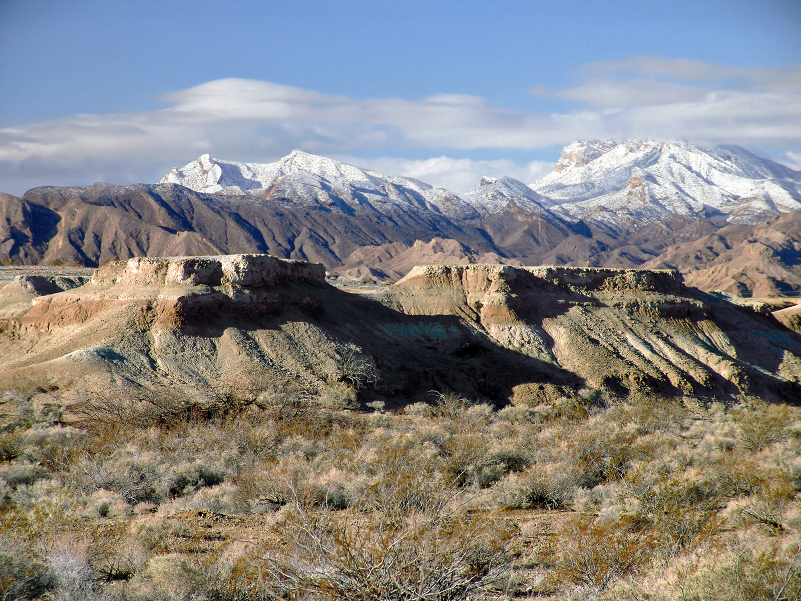
Over the last ~570,000 years, water has transformed the Upper Las Vegas Valley. Tule Springs Fossil Beds National Monument is an urban park that preserves the unique story of this ever-changing enviro...

6 mi from route ~16 min detour Free near mile 14.3
View on nps.gov

Park data from the National Park Service API. Alerts update every 2 hours.

Fuel & Cost

Regular Gas

$82.47 one way

$164.95 round trip

$5.06/gal 25.4 MPG avg 145 kg CO2
Fuel Type $/gal One Way Round Trip
midgrade $5.36 $87.28 $174.56
premium $5.59 $91.13 $182.26
diesel $5.61 $91.41 $182.81

No toll roads detected on this route.

Estimated Trip Cost (one way, 1 person)

Fuel

$82

Hotel (1n)

$80–$140

Meals

$50–$100

Total

$212–$322

Rough estimate based on US averages. Hotel $80–$140/night, meals $25–$50/day.

Estimated CO2 emission: 144.9 kg one way. Prices: EIA weekly data, 2026-04-13.

Driving Electric?

About $43 in charging · 1 stop · 67% less CO2

Vehicle Type kWh Stops DC Fast Home Charge
Average EV 124.2 1 $43.47 $19.87
Efficient EV 103.5 1 $36.22 $16.56
EV Truck/SUV 165.6 2 $57.96 $26.50

Gas CO2

145 kg

EV CO2

48 kg (67% less)

Plan for 1 charging stop. A 30-minute DC fast charge mid-route should be enough to complete the trip comfortably.

DC fast charging avg $0.35/kWh. Home charging avg $0.16/kWh. US grid CO2: 0.39 kg/kWh.

Travel Intel

Current conditions at both ends of the drive.

Forecast as of Apr 15, 2026

Origin

North Las Vegas, NV

Morning in North Las Vegas on Thursday

Local time

9:24 AM

PDT

Current temp

58°F

Unavailable

Live forecast

Destination

Gardnerville, NV

Morning in Gardnerville on Thursday

Local time

9:24 AM

PDT

Current temp

56°F

Unavailable

Live forecast

Seasonal Notes

Summer travel usually means heavier construction, hotter rest stops, and busier weekend traffic around major cities.

Winter travel shortens daylight, so a route that looks manageable on paper can feel much longer after dark.

Holiday weekends tend to make both departure and arrival windows slower than the raw route time suggests.

For long drives, weather on day two can matter just as much as conditions at departure, so check the whole travel window rather than only the first day.

Time zone

Same local time

Origin and destination are on the same clock, so arrival timing is easier to judge at a glance.

Temperature spread

2 degrees cooler at arrival

A meaningful temperature swing is a good cue to rethink layers, water, and how soon you want to arrive.

Road read

8h 21m on the road

This is long enough that the arrival forecast matters almost as much as departure conditions. Recheck both ends before you roll.

Weather data from the National Weather Service. Conditions may change; check closer to your travel date.

Frequently Asked Questions

The drive from North Las Vegas, NV to Gardnerville, NV covers 414 miles and takes about 8h 21m without stops. Add 15-30 minutes for a fuel or rest stop on longer drives.
The main roads are Veterans Memorial Highway, Silver Peak Road, US 95 ALT. Expect a mix of highway and local road driving.
Consider an overnight stop or starting very early.
Yes. This route is usually more comfortable as a 2-day drive. A sensible stopping point is after roughly 207 miles on day one.
The midpoint is about 207 miles from North Las Vegas, NV. Look for rest areas, gas stations, or food options near the halfway mark.
At current regular gas prices, expect to spend about $82.47 one way. This estimate uses 25.4 MPG — your actual cost will vary with your vehicle's fuel efficiency and current gas prices.
Start early — leave by 6-7 AM to arrive at a reasonable hour. This is a long drive — plan for a morning departure or consider splitting it into two days.
Plan about 2 meaningful breaks for fuel, food, or rest. Plan on a short reset every 3 to 4 hours to stay fresh behind the wheel.
This drive requires moderate attention. Across 414 miles you will encounter 21 spots where lane choice or exit timing matters. Not difficult for experienced highway drivers, but worth previewing the tricky sections before you go.
The main spots that need attention: near the start (Constitution Way): Complex interchange - multiple decisions in a short stretch; at 0.7 miles (East Carey Avenue): Roundabout - know your exit number before entering; at 2.3 miles (NV 574 / East Cheyenne Avenue): Lane positioning matters here.
The route from North Las Vegas, NV to Gardnerville, NV does not surface many named destination signs beyond the main corridor.
Yes. Nearby national parks include Tule Springs Fossil Beds National Monument.

Was this helpful?

Thanks for your feedback!

Your tip has been submitted. Thanks!

/500

Explore More

Explore more options from North Las Vegas, NV or browse trips ending in Gardnerville, NV.

Looking for more statewide routes? Browse NV road trips.

Explore maps for North Las Vegas, NV or Gardnerville, NV on MapSof.net.