This 121.7-mile drive from Prairie Ridge, WA to Yakima, WA takes approximately 3 hours and 4 minutes and is best suited for a single day trip. You'll primarily travel on State Route 410 and US 12, with a highway share of 73%, making it a highway-focused journey. The estimated fuel cost for this trip is around $25. This route offers a straightforward path between two points within the Pacific Coast region of Washington. Given its manageable length and duration, it’s an efficient option for a quick transit or a dedicated day of travel.
Trip Pace
Same-day drive is realistic
A same-day return is realistic if you keep stops short.
Break Rhythm
1 planned break
A short stop every 2 to 3 hours is enough for this drive.
Midpoint
60.8 miles from Prairie Ridge, WA
A natural place for your longest stop of the day
, about 1h 34m into the drive
.
Who Is This Route For?
Weekend Trip
Doable as a same-day drive at 3h 4m. Total distance: 121.7 miles.
Family Friendly
Moderate complexity with 1 natural rest stops along the way.
This route is predominantly a highway-focused drive, with 73% of the journey on highways. You'll encounter a longest uninterrupted stretch of 63.5 miles on State Route 410, providing a consistent pace for a significant portion of your travel. The character of the drive is largely defined by these main roads, suggesting a steady and direct experience rather than a winding, scenic byway. Expect a consistent road environment for much of the 121.7 miles.
Most of the miles stay on highways, which makes pacing and fuel planning easier than turn-by-turn city driving.
There are about 19 navigation steps in the underlying route data, so the final approach matters more than the middle miles.
State Route 410 is the longest continuous segment at about 63.5 miles.
How Hard Is This Drive?
This is a straightforward highway drive that stays mostly on State Route 410 and US 12. Navigation is very simple - set it and forget it for most of the drive. The trickiest moment comes around 0.1 miles in near 128th Street Court East.
Driving Effort1/10
Very easy - short and simple to drive
Balances navigation complexity with total wheel time.
The drive from Prairie Ridge, WA to Yakima, WA is easy. At 3h 4m with 73% highway, most drivers will find it relaxed and low-stress.
Where does it get tricky?
The main spots that need attention: at 0.1 miles (128th Street Court East): Complex interchange - multiple decisions in a short stretch; at 0.3 miles (Ridgewood Drive): Complex interchange - multiple decisions in a short stretch; at 2.2 miles (WA 410 / State Route 410 East): Navigation decision point.
Critical Maneuvers
5 of 5 key points
These are the spots where you need to pay the most attention. Preview them before you drive.
6
0.1 mi into trip|~0m in|128th Street Court East
At end of road, turn right onto 128th Street Court East
Complex interchange - multiple decisions in a short stretch
6
0.3 mi into trip|~1m in|Ridgewood Drive
At end of road, turn left onto Ridgewood Drive
Complex interchange - multiple decisions in a short stretch
4
2.2 mi into trip|~5m in|WA 410 / State Route 410 East
Turn right onto WA 410 / State Route 410 East
Navigation decision point
4
2.9 mi into trip|~6m in|WA 410 / State Route 410 East
Enter roundabout onto WA 410 / State Route 410 East
Roundabout - know your exit number before entering
4
119.8 mi into trip|~3h in
Take the exit toward North 1st Street
Exit ramp - move to the correct lane early
Toward North 1st Street
Main Roads
Road
Distance
Duration
State Route 410
63.5 mi
1h 36m
US 12
16.9 mi
22m
Chinook Pass Highway
10 mi
14m
State Route 410 East
8.7 mi
15m
Southeast Enumclaw Chinook Pass Road
6.9 mi
9m
Enumclaw Chinook Pass Road
4.8 mi
6m
Southeast Enumclaw-Chinook Pass Road
3.8 mi
5m
Roosevelt Avenue East
2 mi
3m
Longest stretch:
State Route 410
— 63.5 mi, about 1h 36m
Turn-by-Turn Driving Directions
Step-by-step road directions between Prairie Ridge, WA and Yakima, WA.
1
Start on 211th Avenue Court East
0.1 mi·29 sec·211th Avenue Court East
2
At end of road, turn right onto 128th Street Court East
With a total duration of just over 3 hours, this trip from Prairie Ridge to Yakima offers flexibility. You can easily complete it in one day, leaving ample time to enjoy your destination or depart at your convenience. The longest stretch of 63.5 miles on State Route 410 means you can plan your fuel stops accordingly, likely needing only one major fill-up. Consider departing earlier in the day to maximize daylight, especially if you plan any brief stops along the way. The $25 fuel cost is a good estimate to keep in mind for your budget.
Morning Departure
An early start around 7-8 AM gets you there with plenty of daylight left.
Evening Departure
A late afternoon start means arriving after dark. Morning is better.
You can normally do this drive in one day.
Plan roughly 1 meaningful break for fuel, food, and rest.
The halfway point lands around 60.8 miles from Prairie Ridge, WA, or about 1h 34m into the drive.
The longest continuous stretch on this route runs about 63.5 miles.
This is a comfortable same-day trip.
Departure
Before you leave
Start with fuel, water, and navigation already sorted so the first hour feels easy.
First stop
Around 27 miles or 44m in
Use this first pause for coffee, a restroom break, and a quick traffic check ahead.
Halfway reset
Around 60.8 miles or 1h 34m in
This is the best place for your longest stop, a real meal, and a full fuel check.
Final approach
Final hour starts around 2h 33m
Traffic, exits, and arrival timing usually matter more near Yakima, WA than in the middle of the route.
Before You Leave
+
Open the route before leaving Prairie Ridge, WA so your first major turns are already loaded.
+
Leave with enough water and a charging cable within reach, not packed away.
+
Check your fuel range against the first long segment, especially if you are starting outside city service areas.
Day 1
Settle into the route from Prairie Ridge, WA
This is one driving day of about 121.7 miles and 3h 4m.
Your first comfortable stop window is around 27 miles from Prairie Ridge, WA.
This route can stay practical as a one-day drive if traffic stays reasonable.
Plan about 1 real break rather than only quick fuel stops.
The longest stretch is on State Route 410 for about 63.5 miles.
Where to Stop
Rest stops, refuel points, and overnight suggestions along this route.
Halfway Point
Midpoint
About 60.8 mi from Prairie Ridge, WA
· 1h 34m into the drive
The midpoint is around 60.8 miles from Prairie Ridge, WA, which is a good place for a longer meal and fuel stop.
Before the longest stretch
Fuel check
Top up before State Route 410 if your tank is already low. That segment runs about 63.5 miles.
Arriving in Yakima, WA
The final approach into Yakima, WA usually feels slower than the middle of the drive, so avoid planning your tightest schedule at the very end.
Try to arrive with enough fuel left to skip an immediate station stop unless you already know the area around Yakima, WA.
These stop ideas are pacing suggestions — the exact town or exit can change with traffic, hotel plans, and fuel range.
National Parks Near This Route
Worth a detour if your schedule allows.
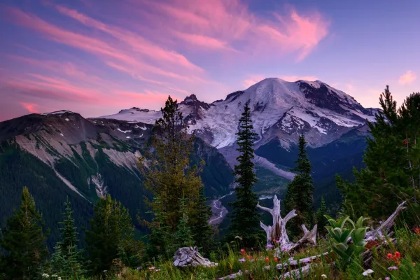
Mount Rainier National Park
National Park
Ascending to 14,410 feet above sea level, Mount Rainier stands as an icon in the Washington landscape. An active volcano, Mount Rainier is the most glaciated peak in the contiguous U.S.A., spawning fi...
8 mi from route
~20 min detour
$30
near mile 50.3
Park Closure: Regular nightly closures of the Longmire gate have ended for the season.
Park Closure: SR 165 Carbon River/Fairfax Bridge is closed: no access to Carbon River or Mowich Lake.
Station data from NREL Alternative Fuel Stations database.
Driving Electric?
About $13 in charging
· 0 stops
· 67% less CO2
Vehicle Type
kWh
Stops
DC Fast
Home Charge
Average EV
36.5
0
$12.78
$5.84
Efficient EV
30.4
0
$10.65
$4.87
EV Truck/SUV
48.7
0
$17.04
$7.79
Gas CO2
43 kg
EV CO2
14 kg (67% less)
This trip is well within single-charge range for most EVs. No charging stops needed if you start fully charged.
DC fast charging avg $0.35/kWh. Home charging avg $0.16/kWh. US grid CO2: 0.39 kg/kWh.
Travel Intel
Current conditions at both ends of the drive.
Forecast as of Apr 15, 2026
Origin
Prairie Ridge, WA
Night
in Prairie Ridge on Friday
Local time
10:35 PM
PDT
Current temp
45°F
Unavailable
Live forecast
Destination
Yakima, WA
Night
in Yakima on Friday
Local time
10:35 PM
PDT
Current temp
46°F
Unavailable
Live forecast
Seasonal Notes
Summer travel usually means heavier construction, hotter rest stops, and busier weekend traffic around major cities.
Winter travel shortens daylight, so a route that looks manageable on paper can feel much longer after dark.
Holiday weekends tend to make both departure and arrival windows slower than the raw route time suggests.
Time zone
Same local time
Origin and destination are on the same clock, so arrival timing is easier to judge at a glance.
Temperature spread
1 degrees warmer at arrival
A meaningful temperature swing is a good cue to rethink layers, water, and how soon you want to arrive.
Road read
3h 4m on the road
Use the two city cards together: check the sky where you start, then compare it with the local time and temperature at arrival.
Weather data from the National Weather Service. Conditions may change; check closer to your travel date.
Frequently Asked Questions
The drive from Prairie Ridge, WA to Yakima, WA covers 121.7 miles and takes about 3h 4m without stops. Add 15-30 minutes for a fuel or rest stop on longer drives.
The main roads are State Route 410, US 12, Chinook Pass Highway. Most of the drive stays on highways, so watch for ramps and exits.
This is a comfortable same-day trip.
The midpoint is about 60.8 miles from Prairie Ridge, WA. Look for rest areas, gas stations, or food options near the halfway mark.
At current regular gas prices, expect to spend about $25.47 one way. This estimate uses 25.4 MPG — your actual cost will vary with your vehicle's fuel efficiency and current gas prices.
An early start around 7-8 AM gets you there with plenty of daylight left. A late afternoon start means arriving after dark. Morning is better.
Plan about 1 meaningful break for fuel, food, or rest. A short stop every 2 to 3 hours is enough for this drive.
The drive from Prairie Ridge, WA to Yakima, WA is easy. At 3h 4m with 73% highway, most drivers will find it relaxed and low-stress.
The main spots that need attention: at 0.1 miles (128th Street Court East): Complex interchange - multiple decisions in a short stretch; at 0.3 miles (Ridgewood Drive): Complex interchange - multiple decisions in a short stretch; at 2.2 miles (WA 410 / State Route 410 East): Navigation decision point.
The route from Prairie Ridge, WA to Yakima, WA does not surface many named destination signs beyond the main corridor.
How this page is built
Compiled by the Trip.ovh planning team at COD Solutions Oy from open government datasets — OSRM over OpenStreetMap for geometry, EIA for fuel prices, NREL for EV charging, and NPS for national parks. See our methodology for refresh cadence and limitations.