Traveling from San Jose to Big Pine covers 300.3 miles and typically takes about 7 hours and 6 minutes. This journey functions well as a single-day trip, though the mixed nature of the drive makes it a substantial commitment. You should set aside a fuel budget of approximately $70 to cover the distance. Navigating through the Pacific Coast region, you will rely on a combination of US 395, Tioga Road, and East F Street. Whether you are looking for a straightforward transit or a transition between these California locales, keeping your schedule flexible is key to managing the total travel time effectively.
Trip Pace
Same-day drive is realistic
A same-day return is possible, but it will make for a full day on the road.
Break Rhythm
2 planned breaks
Plan on a short reset every 3 to 4 hours to stay fresh behind the wheel.
Midpoint
150.2 miles from San Jose, CA
A natural place for your longest stop of the day
, about 3h 24m into the drive
.
Who Is This Route For?
Weekend Trip
Doable as a same-day drive at 7h 6m. Total distance: 300.3 miles.
Family Friendly
Moderate complexity with 2 natural rest stops along the way.
Solo Traveler
7h 6m drive, plan rest stops for pacing.
Scenic Drive
Mixed drive route profile with national parks nearby.
Drive Character
Expect a varied experience behind the wheel, as this 300.3-mile trip is classified as a mixed drive. Only 46% of your time will be spent on highways, meaning you should prepare for shifting road conditions and navigation changes. You will encounter a longest uninterrupted stretch of 61.6 miles on US 395, which provides a welcome rhythm compared to the more technical segments of the route. The transition between different road types requires you to stay alert as the terrain shifts throughout the journey. Overall, the drive offers a balance of fast-moving sections and slower, more deliberate navigation.
Expect a mix of faster highway mileage and slower local approaches near the beginning or end.
There are about 43 navigation steps in the underlying route data, so the final approach matters more than the middle miles.
US 395 is the longest continuous segment at about 61.6 miles.
How Hard Is This Drive?
This route mixes highway mileage with some local-road sections near the start or finish. This route has several spots where lane changes, forks, or exits need your full attention. The trickiest moment comes around 1.5 miles in.
Driving Effort10/10
High effort - long or complex enough to need steady focus all day
Balances navigation complexity with total wheel time.
This is a demanding drive. With 24 significant decision points across 300.3 miles, you will need to stay alert - especially through interchange areas and urban stretches. Consider splitting it into segments if you are not comfortable with fast highway navigation.
Where does it get tricky?
The main spots that need attention: at 1.5 miles: Lane positioning matters here; at 10.9 miles (CA 262): Exit ramp - move to the correct lane early. Lane positioning matters here; at 12.7 miles: Highway fork - watch signs carefully. Lane positioning matters here.
Critical Maneuvers
5 of 24 key points
These are the spots where you need to pay the most attention. Preview them before you drive.
7
1.5 mi into trip|~2m in
Take the ramp toward I 880 North: Oakland
Lane positioning matters here
Use the right lane.
Toward I 880 North: Oakland
7
10.9 mi into trip|~14m in|CA 262
Take the exit onto CA 262 toward Sacramento
Exit ramp - move to the correct lane early. Lane positioning matters here
Use the slight right lane.
Exit 12A
Toward Sacramento
8
12.7 mi into trip|~16m in
Keep slight left at fork toward I 680 North: Sacramento
Highway fork - watch signs carefully. Lane positioning matters here
Use the straight lane.
Toward I 680 North: Sacramento
8
21.5 mi into trip|~27m in|CA 84
Take the exit onto CA 84 toward CA 84 East: Livermore, Vallecitos Road
Exit ramp - move to the correct lane early. Lane positioning matters here. Multiple destination signs - pick the right one
Use the straight / slight right lanes.
Exit 21B
Toward CA 84 East: Livermore, Vallecitos Road
7
68.2 mi into trip|~1h 24m in|CA 120
Take the exit onto CA 120 toward CA 120 East: Sonora, Yosemite Avenue
Exit ramp - move to the correct lane early. Lane positioning matters here. Multiple destination signs - pick the right one
Use the right lane.
Toward CA 120 East: Sonora, Yosemite Avenue
Towns Mentioned on Route Signs
Based on OSRM destination-sign hints, not a full list of every settlement the road passes.
Between San Jose, CA and Big Pine, CA, road signs point toward Stockton and Sonora.
Stockton
44.7 mi in|~57m|via I 205
Sonora
60.3 mi in|~1h 15m
Main Roads
Road
Distance
Duration
US 395
61.6 mi
1h 11m
Tioga Road
58.6 mi
1h 42m
East F Street
25 mi
33m
Main Street
23.5 mi
33m
CA 120
20.7 mi
25m
Robert T. Monagan Freeway
14.6 mi
16m
Arthur H. Breed Junior Freeway
12.9 mi
14m
East Yosemite Avenue
10.7 mi
15m
Longest stretch:
US 395
— 61.6 mi, about 1h 11m
Turn-by-Turn Driving Directions
Step-by-step road directions between San Jose, CA and Big Pine, CA.
1
Start on North Market Street
196 ft·8 sec·North Market Street
2
Continue on Coleman Avenue
1.4 mi·2 min·Coleman Avenue
Use the straight lane.
3
Take the ramp
0.3 mi·42 sec
Toward I 880 North: OaklandUse the right lane.
4
Merge onto I 880
8.5 mi·9 min·I 880
Use the straight / slight right lanes.
5
Keep slight right at fork onto I 880
0.6 mi·41 sec·Nimitz Freeway
6
Take the exit onto CA 262
1.6 mi·2 min·CA 262
Exit 12AToward SacramentoUse the slight right lane.
7
Take the exit
0.2 mi·24 sec
Toward I 680 North: SacramentoUse the straight lane.
8
Keep slight left at fork
0.3 mi·41 sec
Toward I 680 North: SacramentoUse the straight lane.
9
Merge onto I 680
8.5 mi·9 min·I 680
Use the straight / slight right lanes.
10
Take the exit onto CA 84
5.5 mi·7 min·CA 84
Exit 21BToward CA 84 East: Livermore, Vallecitos RoadUse the straight / slight right lanes.
11
Merge onto CA 84
4.3 mi·6 min·Isabel Avenue
Use the straight lane.
12
Take the exit
0.5 mi·1 min
Toward I 580 East: StocktonUse the right lane.
13
Merge onto I 580
13 mi·14 min·Arthur H. Breed Junior Freeway
14
Keep slight left at fork onto I 205
3.9 mi·4 min·Robert T. Monagan Freeway
Toward I 205 East: Tracy, Stockton
15
Keep slight left at fork onto I 205
11 mi·11 min·Robert T. Monagan Freeway
16
Merge onto I 5
1.0 mi·1 min·Westside Freeway
17
Take the exit
469 ft·6 sec
Toward CA 120 East: Manteca, Sonora
18
Continue on CA 120
7.8 mi·8 min·CA 120
Use the straight / slight right lanes.
19
Take the exit onto CA 120
0.3 mi·36 sec·CA 120
Toward CA 120 East: Sonora, Yosemite AvenueUse the right lane.
20
Turn right onto CA 120
11 mi·15 min·East Yosemite Avenue
Use the straight / right lanes.
21
Continue on CA 120
0.2 mi·27 sec·California Street
22
Continue on CA 120
7.1 mi·10 min·Jackson Avenue
23
Continue on CA 120; J9; J14
0.9 mi·1 min·Valley Home Road
24
Continue on CA 120; J9; J14
0.9 mi·2 min·North Yosemite Avenue
25
Turn left onto CA 108; CA 120
25 mi·33 min·East F Street
26
Turn right onto CA 120
13 mi·15 min·CA 120
Use the right lane.
27
Turn right onto Old Priest Grade
1.9 mi·5 min·Old Priest Grade
28
Continue on CA 120
0.8 mi·1 min·New Priest Grade Road
29
Continue on CA 120
2.0 mi·4 min·Highway 120
30
Continue on CA 120
24 mi·33 min·Main Street
31
Continue on Big Oak Flat Road
0.7 mi·1 min·Big Oak Flat Road
32
Continue on Big Oak Flat Road
7.8 mi·16 min·Big Oak Flat Road
33
Turn left onto Tioga Road
59 mi·1 hr 42 min·Tioga Road
34
Continue on US 395; CA 120
18 mi·20 min·US 395; CA 120
Use the straight lane.
35
Continue on US 395
44 mi·50 min·US 395
Use the straight lane.
36
Turn right onto North Barlow Lane
1.0 mi·1 min·North Barlow Lane
37
Turn left onto CA 168
1.5 mi·2 min·West Line Street
38
Turn right onto US 395; CA 168; US 6 Hist
2.4 mi·3 min·South Main Street
39
Continue on US 395; CA 168; US 6 Hist
5.0 mi·5 min·El Camino Sierra
Use the straight / slight right lanes.
40
Continue on US 395; CA 168; US 6 Hist
7.4 mi·8 min·Grand Army of the Republic Highway
Use the straight lane.
41
Continue on US 395; US 6 Hist
0.2 mi·32 sec·North Main Street
42
Continue on US 395; US 6 Hist
462 ft·11 sec·Grand Army of the Republic Highway
43
Arrive at destination
US 395; US 6 Hist
Trip Plan
To make the most of your 7-hour and 6-minute trek, plan for at least 2 strategic stops to break up the drive. Since you are dealing with a 300.3-mile distance, departing early in the morning helps you navigate the varied road segments during daylight hours. Keep a close eye on your fuel gauge, especially when transitioning onto the longer stretches of US 395 where services may be spaced further apart. Because this is a mixed-profile route, ensure your vehicle is comfortable for both highway cruising and the secondary roads you will encounter. Being prepared for these changes in road type is the best way to ensure a smooth arrival in Big Pine.
Morning Departure
Start early — leave by 6-7 AM to arrive at a reasonable hour.
Evening Departure
This is a long drive — plan for a morning departure or consider splitting it into two days.
You can normally do this drive in one day.
Plan roughly 2 meaningful breaks for fuel, food, and rest.
The halfway point lands around 150.2 miles from San Jose, CA, or about 3h 24m into the drive.
The longest continuous stretch on this route runs about 61.6 miles.
This is a comfortable same-day trip.
Departure
Before you leave
Start with fuel, water, and navigation already sorted so the first hour feels easy.
First stop
Around 66 miles or 1h 21m in
Use this first pause for coffee, a restroom break, and a quick traffic check ahead.
Halfway reset
Around 150.2 miles or 3h 24m in
This is the best place for your longest stop, a real meal, and a full fuel check.
Final approach
Final hour starts around 6h
Traffic, exits, and arrival timing usually matter more near Big Pine, CA than in the middle of the route.
Before You Leave
+
Open the route before leaving San Jose, CA so your first major turns are already loaded.
+
Leave with enough water and a charging cable within reach, not packed away.
+
Check your fuel range against the first long segment, especially if you are starting outside city service areas.
+
Pick one backup stop option before the midpoint in case traffic changes your pacing.
Day 1
Settle into the route from San Jose, CA
This is one driving day of about 300.3 miles and 7h 6m.
Your first comfortable stop window is around 66 miles from San Jose, CA.
This route can stay practical as a one-day drive if traffic stays reasonable.
Plan about 2 real breaks rather than only quick fuel stops.
The longest stretch is on US 395 for about 61.6 miles.
Where to Stop
Rest stops, refuel points, and overnight suggestions along this route.
Halfway Point
Midpoint
About 150.2 mi from San Jose, CA
· 3h 24m into the drive
The midpoint is around 150.2 miles from San Jose, CA, which is a good place for a longer meal and fuel stop.
Arriving in Big Pine, CA
The final approach into Big Pine, CA usually feels slower than the middle of the drive, so avoid planning your tightest schedule at the very end.
Try to arrive with enough fuel left to skip an immediate station stop unless you already know the area around Big Pine, CA.
These stop ideas are pacing suggestions — the exact town or exit can change with traffic, hotel plans, and fuel range.
National Parks Near This Route
Worth a detour if your schedule allows.
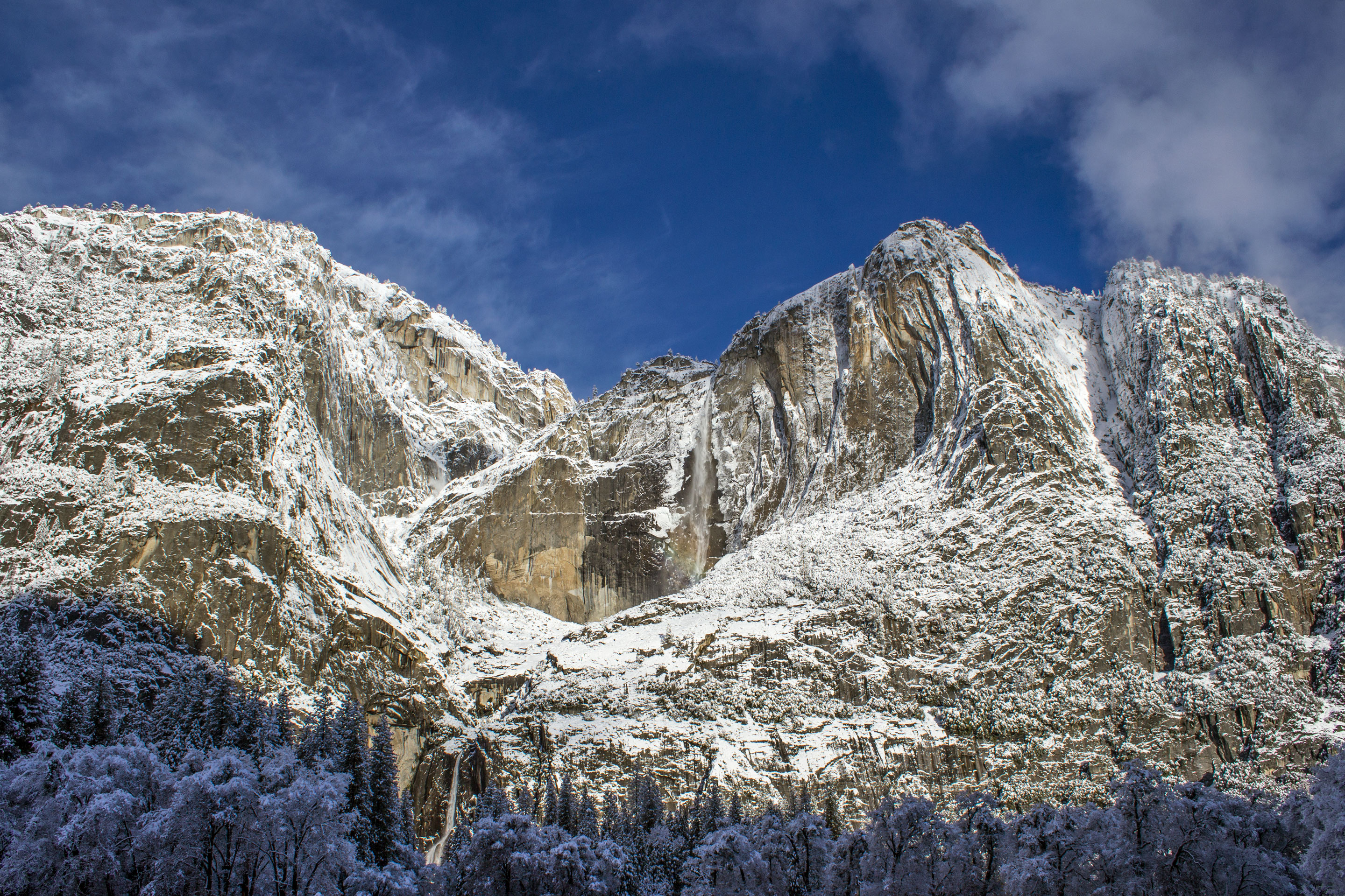
Yosemite National Park
National Park
Not just a great valley, but a shrine to human foresight, the strength of granite, the power of glaciers, the persistence of life, and the tranquility of the High Sierra. First protected in 1864, Yose...
3 mi from route
~7 min detour
$35
near mile 186.4
Park Closure: Tioga Road (Hwy 120 through the park) and Glacier Point Road are closed
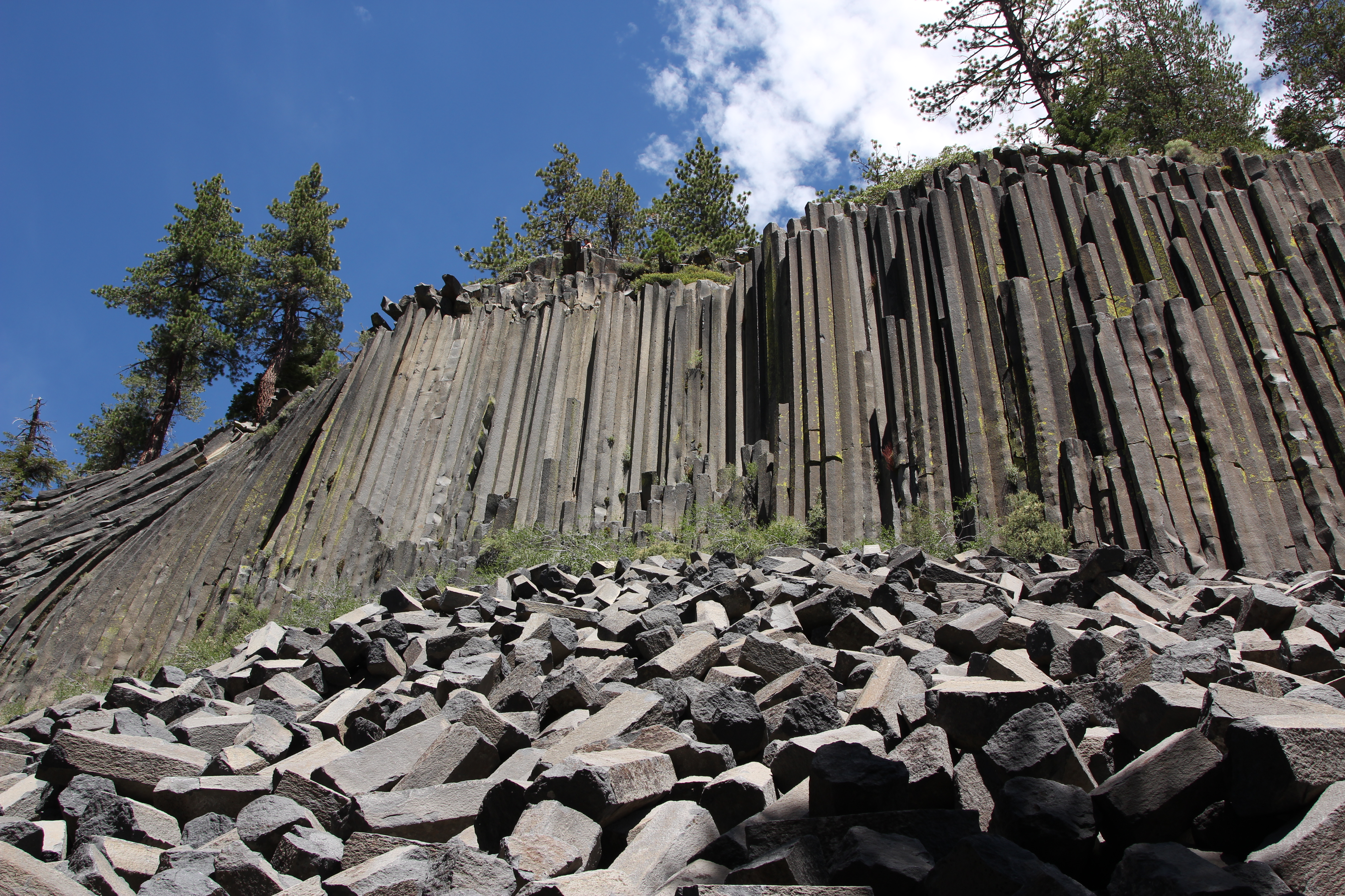
Established in 1911 by presidential proclamation, Devils Postpile National Monument protects and preserves the Devils Postpile formation, the 101-foot high Rainbow Falls, and pristine mountain scenery...
11 mi from route
~27 min detour
Free
near mile 238.2
On July 17, 1944, a massive explosion jolted the San Francisco East Bay area, shattering windows and lighting up the night sky. At Port Chicago Naval Magazine, 320 men were killed instantly when two s...
28 mi from route
~70 min detour
Free
near mile 31.1
Park data from the National Park Service API. Alerts update every 2 hours.
Fuel & Cost
Regular Gas
$69.02 one way
$138.04 round trip
$5.84/gal25.4 MPG avg105 kg CO2
Fuel Type
$/gal
One Way
Round Trip
midgrade
$6.02
$71.13
$142.25
premium
$6.18
$73.03
$146.06
diesel
$5.61
$66.30
$132.60
No toll roads detected on this route.
Estimated Trip Cost (one way, 1 person)
Fuel
$69
Meals
$25–$50
Total
$94–$119
Rough estimate based on US averages. Hotel $80–$140/night, meals $25–$50/day.
Estimated CO2 emission: 105.1 kg one way.
Prices: EIA weekly data, 2026-04-13.
Driving Electric?
About $32 in charging
· 1 stop
· 67% less CO2
Vehicle Type
kWh
Stops
DC Fast
Home Charge
Average EV
90.1
1
$31.53
$14.41
Efficient EV
75.1
0
$26.28
$12.01
EV Truck/SUV
120.1
1
$42.04
$19.22
Gas CO2
105 kg
EV CO2
35 kg (67% less)
Plan for 1 charging stop. A 30-minute DC fast charge mid-route should be enough to complete the trip comfortably.
DC fast charging avg $0.35/kWh. Home charging avg $0.16/kWh. US grid CO2: 0.39 kg/kWh.
Travel Intel
Current conditions at both ends of the drive.
Forecast as of Apr 15, 2026
Origin
San Jose, CA
Morning
in San Jose on Thursday
Local time
9:50 AM
PDT
Current temp
44°F
Unavailable
Live forecast
Destination
Big Pine, CA
Morning
in Big Pine on Thursday
Local time
9:50 AM
PDT
Current temp
41°F
Unavailable
Live forecast
Seasonal Notes
Summer travel usually means heavier construction, hotter rest stops, and busier weekend traffic around major cities.
Winter travel shortens daylight, so a route that looks manageable on paper can feel much longer after dark.
Holiday weekends tend to make both departure and arrival windows slower than the raw route time suggests.
Time zone
Same local time
Origin and destination are on the same clock, so arrival timing is easier to judge at a glance.
Temperature spread
3 degrees cooler at arrival
A meaningful temperature swing is a good cue to rethink layers, water, and how soon you want to arrive.
Road read
7h 6m on the road
Start early — leave by 6-7 AM to arrive at a reasonable hour.
Weather data from the National Weather Service. Conditions may change; check closer to your travel date.
Frequently Asked Questions
The drive from San Jose, CA to Big Pine, CA covers 300.3 miles and takes about 7h 6m without stops. Add 15-30 minutes for a fuel or rest stop on longer drives.
The main roads are US 395, Tioga Road, East F Street. Expect a mix of highway and local road driving.
This is a comfortable same-day trip.
The midpoint is about 150.2 miles from San Jose, CA. Look for rest areas, gas stations, or food options near the halfway mark.
At current regular gas prices, expect to spend about $69.02 one way. This estimate uses 25.4 MPG — your actual cost will vary with your vehicle's fuel efficiency and current gas prices.
Start early — leave by 6-7 AM to arrive at a reasonable hour. This is a long drive — plan for a morning departure or consider splitting it into two days.
Plan about 2 meaningful breaks for fuel, food, or rest. Plan on a short reset every 3 to 4 hours to stay fresh behind the wheel.
This is a demanding drive. With 24 significant decision points across 300.3 miles, you will need to stay alert - especially through interchange areas and urban stretches. Consider splitting it into segments if you are not comfortable with fast highway navigation.
The main spots that need attention: at 1.5 miles: Lane positioning matters here; at 10.9 miles (CA 262): Exit ramp - move to the correct lane early. Lane positioning matters here; at 12.7 miles: Highway fork - watch signs carefully. Lane positioning matters here.
Between San Jose, CA and Big Pine, CA, road signs point toward Stockton and Sonora.