Truckee to Fontana is 453.9 miles and takes about 9h 40m via US 395, with a fuel budget near $104 and best suited for an overnight trip. This drive takes you from the Pacific Coast region of California down to Southern California, offering a mixed driving experience. With a recommended two-day itinerary, you'll have ample time to enjoy the journey without feeling rushed. Consider this route if you're looking for a straightforward path with a manageable fuel cost to get you between these two points in the Golden State.
Trip Pace
Best split across 2 days
Treat the return leg as its own travel day rather than an afterthought.
Break Rhythm
2 planned breaks
Plan on a short reset every 3 to 4 hours to stay fresh behind the wheel.
Midpoint
226.9 miles from Truckee, CA
A natural place for your longest stop of the day
, about 5h 7m into the drive
.
Who Is This Route For?
Family Friendly
Moderate complexity with 2 natural rest stops along the way.
Solo Traveler
9h 40m drive, plan rest stops for pacing.
Scenic Drive
Mixed drive route profile with national parks nearby.
Drive Character
This route presents a mixed drive, with 32% of the journey on highways. You'll experience stretches on US 395, also known as the Grand Army of the Republic Highway and Blue Star Memorial Highway. The longest uninterrupted stretch you'll encounter is 109.1 miles on US 395, offering a good opportunity to settle in. As you progress, the character of the road will likely shift, providing varied driving conditions throughout your trip.
Expect a mix of faster highway mileage and slower local approaches near the beginning or end.
There are about 50 navigation steps in the underlying route data, so the final approach matters more than the middle miles.
US 395 is the longest continuous segment at about 109.1 miles.
How Hard Is This Drive?
This route mixes highway mileage with some local-road sections near the start or finish. You will hit about 25 points where you need to pay attention to lane position or signs. The trickiest moment comes around 0.1 miles in near Bridge Street.
Driving Effort6/10
Moderate - straightforward overall, but long enough or busy enough to require pacing
Balances navigation complexity with total wheel time.
This drive requires moderate attention. Across 453.9 miles you will encounter 25 spots where lane choice or exit timing matters. Not difficult for experienced highway drivers, but worth previewing the tricky sections before you go.
Where does it get tricky?
The main spots that need attention: at 0.1 miles (Bridge Street): Lane positioning matters here; at 51.6 miles (US 395): Lane positioning matters here; at 329.8 miles (US 395 / Blue Star Memorial Highway): Highway fork - watch signs carefully. Lane positioning matters here.
Critical Maneuvers
5 of 25 key points
These are the spots where you need to pay the most attention. Preview them before you drive.
6
0.1 mi into trip|~0m in|Bridge Street
Turn left onto Bridge Street
Lane positioning matters here
Use the left lane.
7
51.6 mi into trip|~1h 22m in|US 395
At end of road, turn right onto US 395
Lane positioning matters here
Use the left lane.
7
329.8 mi into trip|~7h 10m in|US 395 / Blue Star Memorial Highway
Keep slight left at fork onto US 395 / Blue Star Memorial Highway toward US 395 South: San Bernardino
Highway fork - watch signs carefully. Lane positioning matters here
Use the slight left / slight right lanes.
Toward US 395 South: San Bernardino
7
427.1 mi into trip|~9h 7m in
Take the exit toward I 15 South: San Bernardino, Los Angeles
Exit ramp - move to the correct lane early. Lane positioning matters here. Multiple destination signs - pick the right one
Use the straight lane.
Toward I 15 South: San Bernardino, Los Angeles
7
447.3 mi into trip|~9h 29m in
Take the exit toward Sierra Avenue
Exit ramp - move to the correct lane early. Lane positioning matters here
Use the straight / slight right lanes.
Exit 119
Toward Sierra Avenue
Towns Mentioned on Route Signs
Based on OSRM destination-sign hints, not a full list of every settlement the road passes.
On the drive from Truckee, CA to Fontana, CA, road signs begin pointing toward Los Angeles along the way.
Los Angeles
427.1 mi in|~9h 7m
Main Roads
Road
Distance
Duration
US 395
109.1 mi
2h 21m
Grand Army of the Republic Highway
104.6 mi
2h 2m
Blue Star Memorial Highway
103.3 mi
2h 3m
Main Street
43.8 mi
53m
South Carson Street
11 mi
13m
CA 267
10.3 mi
14m
NV 28
10.1 mi
16m
Lincoln Highway
9.8 mi
14m
Longest stretch:
US 395
— 109.1 mi, about 2h 21m
Turn-by-Turn Driving Directions
Step-by-step road directions between Truckee, CA and Fontana, CA.
1
Start on this road
78 ft·11 sec·this road
2
Turn left onto US 40 Hist
249 ft·15 sec·Donner Pass Road
3
Turn left onto Bridge Street
0.2 mi·28 sec·Bridge Street
Use the left lane.
4
Continue on Brockway Road
1.2 mi·2 min·Brockway Road
5
Enter roundabout onto Brockway Road
107 ft·2 sec·Brockway Road
6
Continue on Brockway Road
0.3 mi·36 sec·Brockway Road
7
Turn right onto CA 267
10 mi·14 min·CA 267
8
Turn left onto CA 28
0.4 mi·56 sec·North Lake Boulevard
9
Enter roundabout onto CA 28
69 ft·1 sec·North Lake Boulevard
10
Continue on CA 28
0.1 mi·21 sec·North Lake Boulevard
11
Enter roundabout onto CA 28
66 ft·2 sec·North Lake Boulevard
12
Continue on CA 28
1.2 mi·2 min·North Lake Boulevard
13
Continue on NV 28
2.3 mi·5 min·Tahoe Boulevard
14
Turn right onto Lakeshore Boulevard
3.1 mi·6 min·Lakeshore Boulevard
15
At end of road, turn right onto NV 28
10 mi·16 min·NV 28
16
At end of road, turn left onto US 50
9.8 mi·14 min·Lincoln Highway
17
Turn right onto US 395
11 mi·13 min·South Carson Street
18
Take the exit
488 ft·13 sec
19
Turn straight onto NV 88
0.3 mi·42 sec·Woodfords Road
20
Enter roundabout onto County Road
144 ft·2 sec·County Road
21
Continue on County Road
1.1 mi·2 min·County Road
22
At end of road, turn right onto US 395
66 mi·1 hr 30 min·US 395
Use the left lane.
23
Turn left onto Emigrant Street
0.5 mi·42 sec·Emigrant Street
24
At end of road, turn right onto Sinclair Street
0.1 mi·13 sec·Sinclair Street
25
Turn left onto US 395
44 mi·53 min·Main Street
Use the straight lane.
26
Continue on US 395
44 mi·50 min·US 395
Use the straight lane.
27
Turn right onto North Barlow Lane
1.0 mi·1 min·North Barlow Lane
28
Turn left onto CA 168
1.5 mi·2 min·West Line Street
29
Turn right onto US 395; CA 168; US 6 Hist
2.4 mi·3 min·South Main Street
30
Continue on US 395; CA 168; US 6 Hist
5.0 mi·5 min·El Camino Sierra
Use the straight / slight right lanes.
31
Continue on US 395; CA 168; US 6 Hist
7.4 mi·8 min·Grand Army of the Republic Highway
Use the straight lane.
32
Continue on US 395; US 6 Hist
0.2 mi·32 sec·North Main Street
33
Continue on US 395; US 6 Hist
26 mi·31 min·Grand Army of the Republic Highway
Use the straight lane.
34
Continue on US 395; US 6 Hist
0.7 mi·1 min·North Edwards Street
35
Continue on US 395; US 6 Hist
15 mi·17 min·Grand Army of the Republic Highway
Use the straight lane.
36
Continue on US 395; US 6 Hist
2.2 mi·4 min·North Main Street
37
Continue on US 395; US 6 Hist
56 mi·1 hr 4 min·Grand Army of the Republic Highway
Use the straight lane.
38
Continue on US 395; US 6 Hist
7.0 mi·8 min·Blue Star Memorial Highway
Use the straight lane.
39
Keep slight left at fork onto US 395
30 mi·34 min·Blue Star Memorial Highway
Toward US 395 South: San BernardinoUse the slight left / slight right lanes.
40
Continue on US 395
0.9 mi·1 min·Red Mountain Road
41
Continue on US 395
67 mi·1 hr 20 min·Blue Star Memorial Highway
Use the straight lane.
42
Take the exit
0.7 mi·1 min
Toward I 15 South: San Bernardino, Los AngelesUse the straight lane.
43
Merge onto I 15; US 66 Hist
3.4 mi·3 min·Barstow and Mojave Freeway
Use the straight / slight right lanes.
44
Continue on I 15; US 66 Hist; US 91 Hist; US 395 Hist
5.6 mi·6 min·CHP Officer Larry L. Wetterling and San Bernardino County Sheriff's Lieutenant Alfred E. Stewart Memorial Highway
Use the straight / slight right lanes.
45
Continue on I 15; US 66 Hist
6.3 mi·6 min·Barstow and Mojave Freeway
Use the straight / slight right lanes.
46
Take the exit onto I 15
4.3 mi·4 min·I 15
47
Take the exit
0.2 mi·38 sec
Exit 119Toward Sierra AvenueUse the straight / slight right lanes.
48
Turn left onto Sierra Avenue
6.2 mi·9 min·Sierra Avenue
Use the left lane.
49
Turn left onto Merrill Avenue
205 ft·4 sec·Merrill Avenue
Use the left lane.
50
Arrive at destination
Merrill Avenue
Trip Plan
Given the 9h 40m estimated duration, splitting this 453.9-mile drive over two days is highly recommended for a more relaxed pace. Aim to start your first day early to maximize daylight, especially if traveling during shorter daylight months. Plan for at least two stops to refuel and stretch, considering the longest stretch is over 100 miles. Keep an eye on your fuel levels, as services can be spread out on certain sections of US 395, and factor in the $104 fuel cost for your budget.
Morning Departure
Start early — leave by 6-7 AM to arrive at a reasonable hour.
Evening Departure
This is a long drive — plan for a morning departure or consider splitting it into two days.
This drive is better paced as a 2-day trip.
Plan roughly 2 meaningful breaks for fuel, food, and rest.
The halfway point lands around 226.9 miles from Truckee, CA, or about 5h 7m into the drive.
The longest continuous stretch on this route runs about 109.1 miles.
Consider an overnight stop or starting very early.
Departure
Before you leave
Start with fuel, water, and navigation already sorted so the first hour feels easy.
First stop
Around 100 miles or 2h 29m in
Use this first pause for coffee, a restroom break, and a quick traffic check ahead.
Halfway reset
Around 226.9 miles or 5h 7m in
This is the best place for your longest stop, a real meal, and a full fuel check.
Overnight split
Day 1 wrap after about 226.9 miles or 5h 7m
Stop before fatigue turns the last few hours into a grind. You want day two to start fresh, not just resumed.
Final approach
Final hour starts around 8h 27m
Traffic, exits, and arrival timing usually matter more near Fontana, CA than in the middle of the route.
Before You Leave
+
Open the route before leaving Truckee, CA so your first major turns are already loaded.
+
Leave with enough water and a charging cable within reach, not packed away.
+
Check your fuel range against the first long segment, especially if you are starting outside city service areas.
+
Pick one backup stop option before the midpoint in case traffic changes your pacing.
+
Treat this as a 2-day road trip and book the overnight stop before the busiest arrival window.
Day 1
Settle into the route from Truckee, CA
Aim for roughly 227 miles and 4.8 hours of wheel time on this day.
Day 2
Finish the approach into Fontana, CA
Aim for roughly 227 miles and 4.8 hours of wheel time on this day.
Your first comfortable stop window is around 100 miles from Truckee, CA.
This route usually feels better as a 2-day drive than as one long push.
Plan about 2 real breaks rather than only quick fuel stops.
The longest stretch is on US 395 for about 109.1 miles.
Where to Stop
Rest stops, refuel points, and overnight suggestions along this route.
Halfway Point
Midpoint
About 226.9 mi from Truckee, CA
· 5h 7m into the drive
The midpoint is around 226.9 miles from Truckee, CA, which is a good place for a longer meal and fuel stop.
Before the longest stretch
Fuel check
Top up before US 395 if your tank is already low. That segment runs about 109.1 miles.
Overnight split
Hotel stop
For a steadier pace, wrap day one after about 227 miles or 4.8 hours on the road.
Arriving in Fontana, CA
The final approach into Fontana, CA usually feels slower than the middle of the drive, so avoid planning your tightest schedule at the very end.
Try to arrive with enough fuel left to skip an immediate station stop unless you already know the area around Fontana, CA.
On a multi-day trip, keep the last day a little lighter so you reach Fontana, CA with some flexibility left in the schedule.
After long uninterrupted mileage, take five minutes before the last urban segment to reset and refocus on exits, merges, and city traffic.
These stop ideas are pacing suggestions — the exact town or exit can change with traffic, hotel plans, and fuel range.
National Parks Near This Route
Worth a detour if your schedule allows.
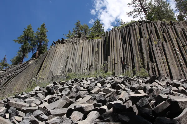
Devils Postpile National Monument
National Monument
Established in 1911 by presidential proclamation, Devils Postpile National Monument protects and preserves the Devils Postpile formation, the 101-foot high Rainbow Falls, and pristine mountain scenery...
12 mi from route
~31 min detour
Free
near mile 156.5
Park Closure: Reds Meadow Road Access Restrictions in 2026
Park Closure: Devils Postpile National Monument facilities are closed for the season
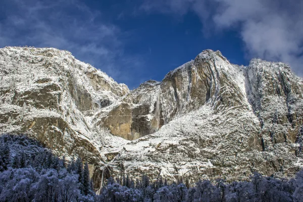
Not just a great valley, but a shrine to human foresight, the strength of granite, the power of glaciers, the persistence of life, and the tranquility of the High Sierra. First protected in 1864, Yose...
25 mi from route
~61 min detour
$35
near mile 140.9
Station data from NREL Alternative Fuel Stations database.
Driving Electric?
About $48 in charging
· 1 stop
· 67% less CO2
Vehicle Type
kWh
Stops
DC Fast
Home Charge
Average EV
136.2
1
$47.66
$21.79
Efficient EV
113.5
1
$39.72
$18.16
EV Truck/SUV
181.6
2
$63.55
$29.05
Gas CO2
159 kg
EV CO2
53 kg (67% less)
Plan for 1 charging stop. A 30-minute DC fast charge mid-route should be enough to complete the trip comfortably.
DC fast charging avg $0.35/kWh. Home charging avg $0.16/kWh. US grid CO2: 0.39 kg/kWh.
Travel Intel
Current conditions at both ends of the drive.
Forecast as of Apr 15, 2026
Origin
Truckee, CA
Late night
in Truckee on Friday
Local time
4:02 AM
PDT
Current temp
45°F
Unavailable
Live forecast
Destination
Fontana, CA
Late night
in Fontana on Friday
Local time
4:02 AM
PDT
Current temp
76°F
Unavailable
Live forecast
Seasonal Notes
Summer travel usually means heavier construction, hotter rest stops, and busier weekend traffic around major cities.
Winter travel shortens daylight, so a route that looks manageable on paper can feel much longer after dark.
Holiday weekends tend to make both departure and arrival windows slower than the raw route time suggests.
For long drives, weather on day two can matter just as much as conditions at departure, so check the whole travel window rather than only the first day.
Time zone
Same local time
Origin and destination are on the same clock, so arrival timing is easier to judge at a glance.
Temperature spread
31 degrees warmer at arrival
A meaningful temperature swing is a good cue to rethink layers, water, and how soon you want to arrive.
Road read
9h 40m on the road
This is long enough that the arrival forecast matters almost as much as departure conditions. Recheck both ends before you roll.
Weather data from the National Weather Service. Conditions may change; check closer to your travel date.
Frequently Asked Questions
The drive from Truckee, CA to Fontana, CA covers 453.9 miles and takes about 9h 40m without stops. Add 15-30 minutes for a fuel or rest stop on longer drives.
The main roads are US 395, Grand Army of the Republic Highway, Blue Star Memorial Highway. Expect a mix of highway and local road driving.
Consider an overnight stop or starting very early.
Yes. This route is usually more comfortable as a 2-day drive. A sensible stopping point is after roughly 227 miles on day one.
The midpoint is about 226.9 miles from Truckee, CA. Look for rest areas, gas stations, or food options near the halfway mark.
At current regular gas prices, expect to spend about $104.33 one way. This estimate uses 25.4 MPG — your actual cost will vary with your vehicle's fuel efficiency and current gas prices.
Start early — leave by 6-7 AM to arrive at a reasonable hour. This is a long drive — plan for a morning departure or consider splitting it into two days.
Plan about 2 meaningful breaks for fuel, food, or rest. Plan on a short reset every 3 to 4 hours to stay fresh behind the wheel.
This drive requires moderate attention. Across 453.9 miles you will encounter 25 spots where lane choice or exit timing matters. Not difficult for experienced highway drivers, but worth previewing the tricky sections before you go.
The main spots that need attention: at 0.1 miles (Bridge Street): Lane positioning matters here; at 51.6 miles (US 395): Lane positioning matters here; at 329.8 miles (US 395 / Blue Star Memorial Highway): Highway fork - watch signs carefully. Lane positioning matters here.
On the drive from Truckee, CA to Fontana, CA, road signs begin pointing toward Los Angeles along the way.
How this page is built
Compiled and maintained by the Trip.ovh planning team at COD Solutions Oy (Helsinki). Each route is built from authoritative open government and mapping datasets rather than crowdsourced reviews. Distances and geometry come from
OSRM
over
OpenStreetMap.
Fuel cost uses
EIA
weekly regional averages.
EV charging comes from the
NREL Alternative Fuels
dataset.
National park proximity is from the
NPS API.
Pages are published only after passing our data-quality checks; our
methodology page
documents refresh cadence, editorial standards, and known limitations.