Origin
Friars Point, MS
Afternoon in Friars Point on Saturday
Local time
1:12 PM
CDT
Current temp
56°F
Unavailable
Live forecast
Compiled and reviewed by the Trip.ovh planning team at COD Solutions Oy · Last reviewed Apr 18, 2026 · Editorial standards
Drive Time
2h 49m
Distance
120.5 mi
194 km
Drive Score
8/10
Great drive
Same Day?
Yes, doable
Fuel Cost
$18
one way
EV Charging
Unknown
Estimated drive times based on typical traffic patterns. Actual times may vary with weather, construction, and real-time conditions.

Friars Point, MS
Wikimedia Commons

Tupelo, MS
Wikimedia Commons
The drive from Friars Point, MS to Tupelo, MS covers 120.5 miles and takes about 2h 49m behind the wheel. This route is realistic as a one-day drive if you keep your stops efficient.
The route leans on US 278, MS 6, MS 316 for much of the mileage, and the overall profile is mostly highway. The longest uninterrupted segment is about 63.5 miles on US 278. At current regular gas prices, budget about $18.20 one way before food or hotel costs.
Trip Pace
Same-day drive is realistic
A same-day return is realistic if you keep stops short.
Break Rhythm
1 planned break
A short stop every 2 to 3 hours is enough for this drive.
Midpoint
60.2 miles from Friars Point, MS
A natural place for your longest stop of the day , about 1h 31m into the drive .
| Road | Distance | Duration |
|---|---|---|
| US 278 | 63.5 mi | 1h 21m |
| MS 6 | 21.2 mi | 24m |
| MS 316 | 10.3 mi | 14m |
| Friar Point Road | 8.8 mi | 21m |
| West Main Street | 5.7 mi | 11m |
| Old Highway 6 | 5.6 mi | 7m |
| Jonestown Road | 4.2 mi | 5m |
| Sheriff Ridge Avenue | 0.3 mi | <1m |
Step-by-step road directions between Friars Point, MS and Tupelo, MS.
Start on 3rd Street
At end of road, turn left onto Washington Street
Turn right onto Sheriff Ridge Avenue
Turn left onto Friar Point Road
Continue on Jonestown Road
Continue on MS 316
At end of road, turn left onto US 278; MS 6
Continue on MS 6; US 278
Continue on US 278; MS 6
Take the exit
Turn straight onto Old Highway 6
Continue on West Main Street
Turn left onto North Spring Street
Arrive at destination
Morning Departure
Leave by 9 AM and you'll arrive before lunch.
Evening Departure
Even a 4 PM departure gets you there before dark in summer.
This is a comfortable same-day trip.
Departure
Before you leave
Start with fuel, water, and navigation already sorted so the first hour feels easy.
First stop
Around 27 miles or 47m in
Use this first pause for coffee, a restroom break, and a quick traffic check ahead.
Halfway reset
Around 60.2 miles or 1h 31m in
This is the best place for your longest stop, a real meal, and a full fuel check.
Final approach
Final hour starts around 2h 17m
Traffic, exits, and arrival timing usually matter more near Tupelo, MS than in the middle of the route.
Open the route before leaving Friars Point, MS so your first major turns are already loaded.
Leave with enough water and a charging cable within reach, not packed away.
Check your fuel range against the first long segment, especially if you are starting outside city service areas.
Day 1
Settle into the route from Friars Point, MS
This is one driving day of about 120.5 miles and 2h 49m.
Rest stops, refuel points, and overnight suggestions along this route.

Mid-route town
Meal stop
60 mi into the route
Best for: Lunch, fuel, and a longer reset
This sits close to the middle of the route, so it works well for the longest stop of the day.
A short stop after about 27 miles helps settle the day before fatigue starts building.
The midpoint is around 60.2 miles from Friars Point, MS, which is a good place for a longer meal and fuel stop.
Before the longest stretch
Fuel checkTop up before US 278 if your tank is already low. That segment runs about 63.5 miles.
These stop ideas are pacing suggestions — the exact town or exit can change with traffic, hotel plans, and fuel range.
5 decision points cluster between mile 0.1 and 120.4 — GPS handles the exact turns, but know they're coming. Your lane choice matters more than the turn itself.
At end of road, turn left onto Washington Street
Navigation decision point
Turn right onto Sheriff Ridge Avenue
Navigation decision point
Turn left onto Friar Point Road
Navigation decision point
At end of road, turn left onto US 278; MS 6
Lane positioning matters here
Turn left onto North Spring Street
Navigation decision point
Regular Gas
$18.20 one way
$36.40 round trip
| Fuel Type | $/gal | One Way | Round Trip |
|---|---|---|---|
| midgrade | $4.21 | $19.98 | $39.95 |
| premium | $4.56 | $21.63 | $43.26 |
| diesel | $5.61 | $26.60 | $53.21 |
No toll roads detected on this route.
Estimated Trip Cost (one way, 1 person)
Fuel
$18
Meals
$25–$50
Total
$43–$68
Rough estimate based on US averages. Hotel $80–$140/night, meals $25–$50/day.
Estimated CO2 emission: 42.2 kg one way. Prices: EIA weekly data, 2026-04-13.
Driving Electric?
About $13 in charging · 0 stops · 67% less CO2
| Vehicle Type | kWh | Stops | DC Fast | Home Charge |
|---|---|---|---|---|
| Average EV | 36.2 | 0 | $12.65 | $5.78 |
| Efficient EV | 30.1 | 0 | $10.54 | $4.82 |
| EV Truck/SUV | 48.2 | 0 | $16.87 | $7.71 |
Gas CO2
42 kg
EV CO2
14 kg (67% less)
This trip is well within single-charge range for most EVs. No charging stops needed if you start fully charged.
DC fast charging avg $0.35/kWh. Home charging avg $0.16/kWh. US grid CO2: 0.39 kg/kWh.
Current conditions at both ends of the drive.
Origin
Afternoon in Friars Point on Saturday
Local time
1:12 PM
CDT
Current temp
56°F
Unavailable
Destination
Afternoon in Tupelo on Saturday
Local time
1:12 PM
CDT
Current temp
78°F
Unavailable
77°F
Batesville, MS
60 mi in
Seasonal Notes
Summer travel usually means heavier construction, hotter rest stops, and busier weekend traffic around major cities.
Winter travel shortens daylight, so a route that looks manageable on paper can feel much longer after dark.
Holiday weekends tend to make both departure and arrival windows slower than the raw route time suggests.
Time zone
Origin and destination are on the same clock, so arrival timing is easier to judge at a glance.
Temperature spread
A meaningful temperature swing is a good cue to rethink layers, water, and how soon you want to arrive.
Road read
Use the two city cards together: check the sky where you start, then compare it with the local time and temperature at arrival.
Weather data from the National Weather Service. Conditions may change; check closer to your travel date.
Worth a detour if your schedule allows.
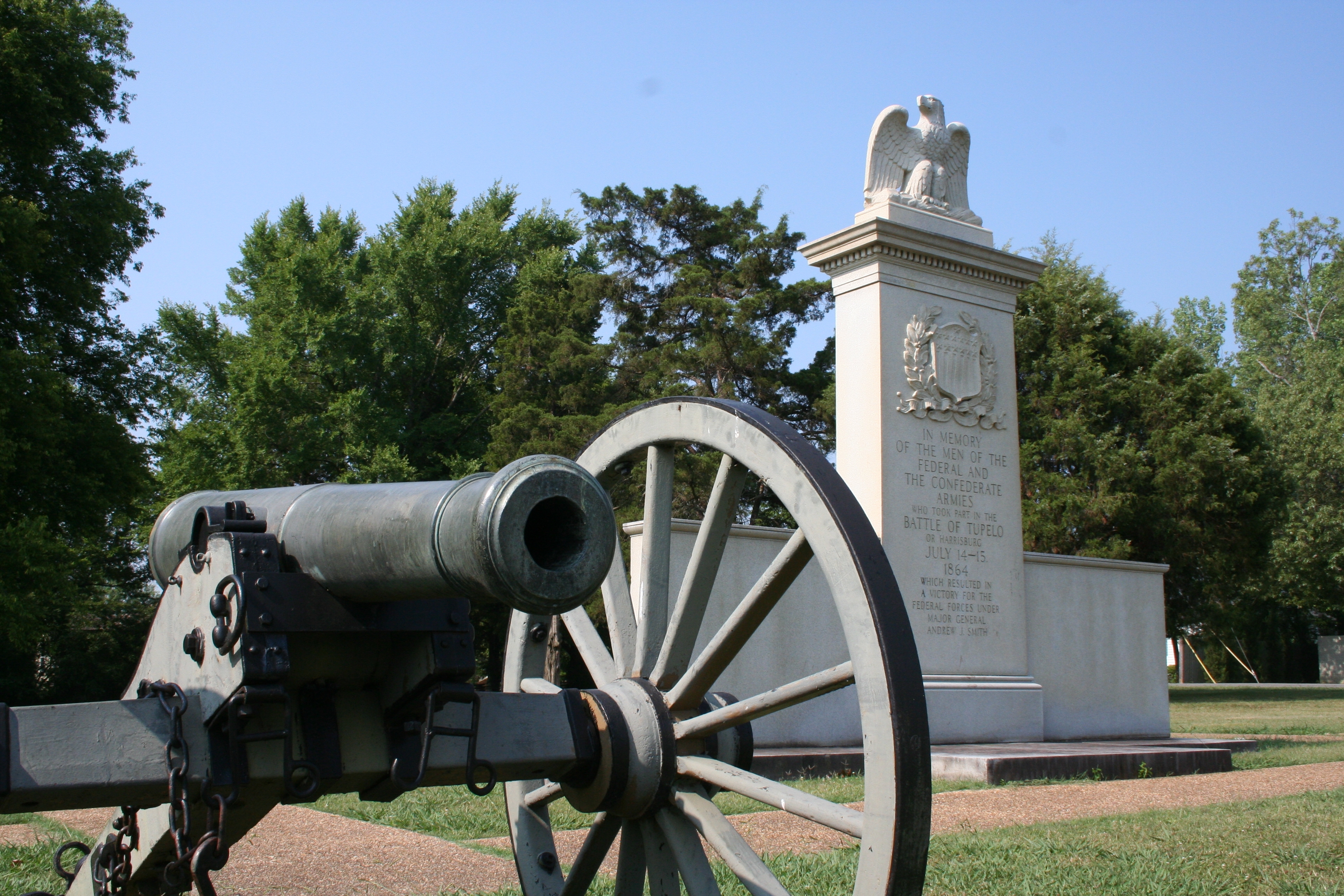
National Battlefield
In July, 1864, federal forces, including men from the United States Colored Troops, marched into Tupelo, Mississippi. Disorganized Confederate soldiers fought fiercely but could not overpower the fede...
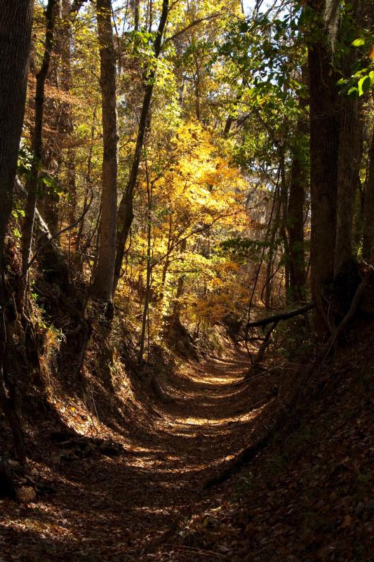
National Scenic Trail
The Natchez Trace National Scenic Trail is five sections of hiking trail running roughly parallel to the 444-mile long Natchez Trace Parkway scenic motor road. The foot trails total more than 60 miles...
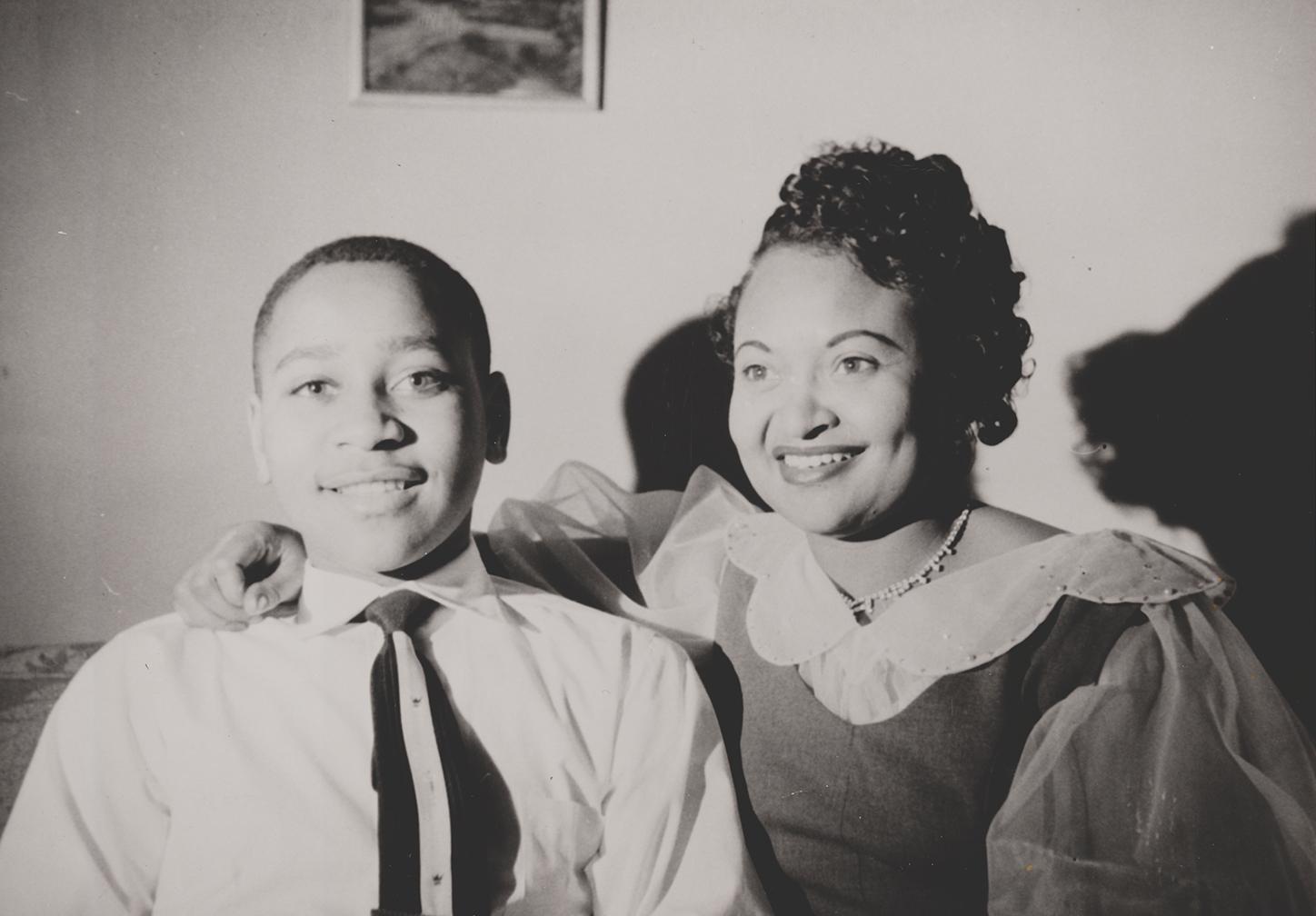
National Monument
In 1955, 14-year-old Emmett Till traveled to Money, Mississippi, to visit relatives. He was kidnapped, tortured, and murdered after reportedly whistling at a white woman. His mother, Mamie Till-Mobley...
Park data from the National Park Service API. Alerts update every 2 hours.
120.5 mi in 2h 49m, mostly highway — 63.5 mi of that is on US 278.
This is a straightforward highway drive that stays mostly on US 278 and MS 6. Navigation is very simple - set it and forget it for most of the drive. The trickiest moment comes around 0.1 miles in near Washington Street.
Very easy - short and simple to drive
Balances navigation complexity with total wheel time.
The drive from Friars Point, MS to Tupelo, MS is easy. At 2h 49m with 83% highway, most drivers will find it relaxed and low-stress.
Where does it get tricky?
The main spots that need attention: at 0.1 miles (Washington Street): Navigation decision point; at 0.2 miles (Sheriff Ridge Avenue): Navigation decision point; at 0.5 miles (Friar Point Road): Navigation decision point.
Mostly flat terrain
Total Climb
39 ft
Total Descent
5 ft
Highest Point
210 ft
~43 mi in
Elevation Range
39 ft
Weekend Trip
Doable as a same-day drive at 2h 49m. Total distance: 120.5 miles.
Family Friendly
Moderate complexity with 1 natural rest stops along the way.
Solo Traveler
2h 49m drive, comfortable solo distance.
First-Time Driver
Mostly highway driving (83%). Straightforward navigation.
Compiled by the Trip.ovh planning team at COD Solutions Oy from open government datasets — OSRM over OpenStreetMap for geometry, EIA for fuel prices, USGS 3DEP for elevation, and NPS for national parks. See our methodology for refresh cadence and limitations.
Was this helpful?
Thanks for your feedback!
Your tip has been submitted. Thanks!
/500
Recent Tips
·
Explore more options from Friars Point, MS or browse trips ending in Tupelo, MS.
Looking for more statewide routes? Browse MS road trips.