
Trip from Saint George, UT to West Mountain, UT

Last recalculated Apr 16, 2026

Drive Time

4h 8m

Distance

248.2 mi

399 km

Drive Score

8/10

Great drive

Same Day?

Yes, doable

Fuel Cost

$39

one way

EV Charging

Unknown

Best Time to Leave

Save up to 40 min
4 AM
3h 55m ★
6 AM
4h 8m
8 AM
4h 35m
10 AM
4h 18m
12 PM
4h 15m
3 PM
4h 19m
5 PM
4h 33m
8 PM
4h 1m

Estimated drive times based on typical traffic patterns. Actual times may vary with weather, construction, and real-time conditions.

city in Washington County, Utah, United States

Saint George, UT

Wikimedia Commons

Downtown West Mountain, UT, UT

West Mountain, UT

Quang Vuong

Trip Overview

The drive from Saint George, UT to West Mountain, UT covers 248.2 miles and takes about 4h 8m behind the wheel. This route is realistic as a one-day drive if you keep your stops efficient.

The route leans on Veterans Memorial Highway, 9600 South, Saint George Boulevard for much of the mileage, and the overall profile is turn-heavy local drive. The longest uninterrupted segment is about 242.1 miles on Veterans Memorial Highway. At current regular gas prices, budget about $39.33 one way before food or hotel costs.

Trip Pace

Same-day drive is realistic

A same-day return is possible, but it will make for a full day on the road.

Break Rhythm

1 planned break

Plan on a short reset every 3 to 4 hours to stay fresh behind the wheel.

Midpoint

124.1 miles from Saint George, UT

A natural place for your longest stop of the day , about 2h 4m into the drive .

Who Is This Route For?

Weekend Trip

Doable as a same-day drive at 4h 8m. Total distance: 248.2 miles.

Family Friendly

Moderate complexity with 1 natural rest stops along the way.

Solo Traveler

4h 8m drive, comfortable solo distance.

First-Time Driver

Mostly highway driving (0%). Straightforward navigation.

Scenic Drive

Turn-heavy local drive route profile with national parks nearby.

Drive Character

Expect a 4h 8m drive with frequent turns across 248.2 miles of local and secondary roads.

This route has more turning and local-road decision points than a simple highway run.
There are about 15 navigation steps in the underlying route data, so the final approach matters more than the middle miles.
Veterans Memorial Highway is the longest continuous segment at about 242.1 miles.

How Hard Is This Drive?

Expect a hands-on drive with frequent turns and local roads rather than long highway stretches. There are only a few real navigation decisions along the way. The trickiest moment comes around 0.1 miles in near 100 West.

Driving Effort 3/10

Easy - simple navigation with a manageable amount of wheel time

Balances navigation complexity with total wheel time.

This is a straightforward 4h 8m drive. You will face about 12 decision points, but nothing that requires special attention if you follow navigation.

Where does it get tricky?

The main spots that need attention: at 0.1 miles (100 West): Navigation decision point; at 0.2 miles (200 South): Navigation decision point; at 0.5 miles (Main Street): Roundabout - know your exit number before entering.

Critical Maneuvers

5 of 12 key points

These are the spots where you need to pay the most attention. Preview them before you drive.

5
0.1 mi into trip | ~0m in | 100 West

Turn right onto 100 West

Navigation decision point

5
0.2 mi into trip | ~0m in | 200 South

Turn right onto 200 South

Navigation decision point

5
0.5 mi into trip | ~2m in | Main Street

Enter roundabout onto Main Street

Roundabout - know your exit number before entering

5
2.1 mi into trip | ~6m in | I 15 BUS

Take the ramp onto I 15 BUS toward I 15 North: Salt Lake City

Lane positioning matters here

Use the slight left / straight lanes. Toward I 15 North: Salt Lake City
9
244.6 mi into trip | ~4h 1m in

Keep slight left at fork toward SR 115: Payson Main Street, Benjamin

Highway fork - watch signs carefully. Lane positioning matters here. Multiple destination signs - pick the right one

Use the slight left / slight right lanes. Toward SR 115: Payson Main Street, Benjamin

Main Roads

Road Distance Duration
Veterans Memorial Highway 242.1 mi 3h 54m
9600 South 3 mi 5m
Saint George Boulevard 1.4 mi 3m
Main Street 0.5 mi 1m
South 5600 West Street 0.4 mi <1m
I 15 BUS 0.3 mi <1m
200 South 0.1 mi <1m
100 West <0.1 mi <1m
Longest stretch: Veterans Memorial Highway — 242.1 mi, about 3h 54m

Turn-by-Turn Driving Directions

Step-by-step road directions between Saint George, UT and West Mountain, UT.

1

Start on this road

510 ft · 39 sec · this road
2

Turn right onto 100 West

387 ft · 19 sec · 100 West
3

Turn right onto 200 South

0.1 mi · 32 sec · 200 South
4

Turn left onto Main Street

0.2 mi · 36 sec · Main Street
5

Enter roundabout onto Main Street

82 ft · 1 sec · Main Street
6

Continue on Main Street

0.1 mi · 15 sec · Main Street
7

Turn right onto I 15 BUS; SR 34

1.4 mi · 3 min · Saint George Boulevard
8

Take the ramp onto I 15 BUS

0.3 mi · 43 sec · I 15 BUS
Toward I 15 North: Salt Lake City Use the slight left / straight lanes.
9

Merge onto I 15

242 mi · 3 hr 54 min · Veterans Memorial Highway
10

Take the exit

0.2 mi · 21 sec
Exit 250 Toward SR 115: Payson Main Street
11

Keep slight left at fork

126 ft · 6 sec
Toward SR 115: Payson Main Street, Benjamin Use the slight left / slight right lanes.
12

Turn left onto SR 115

0.2 mi · 34 sec · Main Street
13

Turn left onto 9600 South

3.0 mi · 5 min · 9600 South
14

Turn right onto SR 147

0.4 mi · 52 sec · South 5600 West Street
15

Arrive at destination

SR 147

Trip Plan

Morning Departure

An early start around 7-8 AM gets you there with plenty of daylight left.

Evening Departure

A late afternoon start means arriving after dark. Morning is better.

You can normally do this drive in one day.
Plan roughly 1 meaningful break for fuel, food, and rest.
The halfway point lands around 124.1 miles from Saint George, UT, or about 2h 4m into the drive.
The longest continuous stretch on this route runs about 242.1 miles.

This is a comfortable same-day trip.

Departure

Before you leave

Start with fuel, water, and navigation already sorted so the first hour feels easy.

First stop

Around 55 miles or 57m in

Use this first pause for coffee, a restroom break, and a quick traffic check ahead.

Halfway reset

Around 124.1 miles or 2h 4m in

This is the best place for your longest stop, a real meal, and a full fuel check.

Final approach

Final hour starts around 3h 21m

Traffic, exits, and arrival timing usually matter more near West Mountain, UT than in the middle of the route.

Before You Leave

+

Open the route before leaving Saint George, UT so your first major turns are already loaded.

+

Leave with enough water and a charging cable within reach, not packed away.

+

Check your fuel range against the first long segment, especially if you are starting outside city service areas.

Day 1

Settle into the route from Saint George, UT

This is one driving day of about 248.2 miles and 4h 8m.

Your first comfortable stop window is around 55 miles from Saint George, UT.
This route can stay practical as a one-day drive if traffic stays reasonable.
Plan about 1 real break rather than only quick fuel stops.
The longest stretch is on Veterans Memorial Highway for about 242.1 miles.

Where to Stop

Rest stops, refuel points, and overnight suggestions along this route.

Halfway Point

Midpoint

About 124.1 mi from Saint George, UT · 2h 4m into the drive

city in Beaver County, Utah, United States

Mid-route town

Meal stop

Beaver, UT

124 mi into the route

Best for: Lunch, fuel, and a longer reset

This sits close to the middle of the route, so it works well for the longest stop of the day.

Pacing Suggestions

Cedar City, UT

Fuel and coffee

A short stop after about 55 miles helps settle the day before fatigue starts building.

Beaver, UT

Meal break

The midpoint is around 124.1 miles from Saint George, UT, which is a good place for a longer meal and fuel stop.

Before the longest stretch

Fuel check

Top up before Veterans Memorial Highway if your tank is already low. That segment runs about 242.1 miles.

Arriving in West Mountain, UT

The final approach into West Mountain, UT usually feels slower than the middle of the drive, so avoid planning your tightest schedule at the very end.

Try to arrive with enough fuel left to skip an immediate station stop unless you already know the area around West Mountain, UT.

After long uninterrupted mileage, take five minutes before the last urban segment to reset and refocus on exits, merges, and city traffic.

These stop ideas are pacing suggestions — the exact town or exit can change with traffic, hotel plans, and fuel range.

National Parks Near This Route

Worth a detour if your schedule allows.

Cedar Breaks National Monument

Cedar Breaks National Monument

National Monument

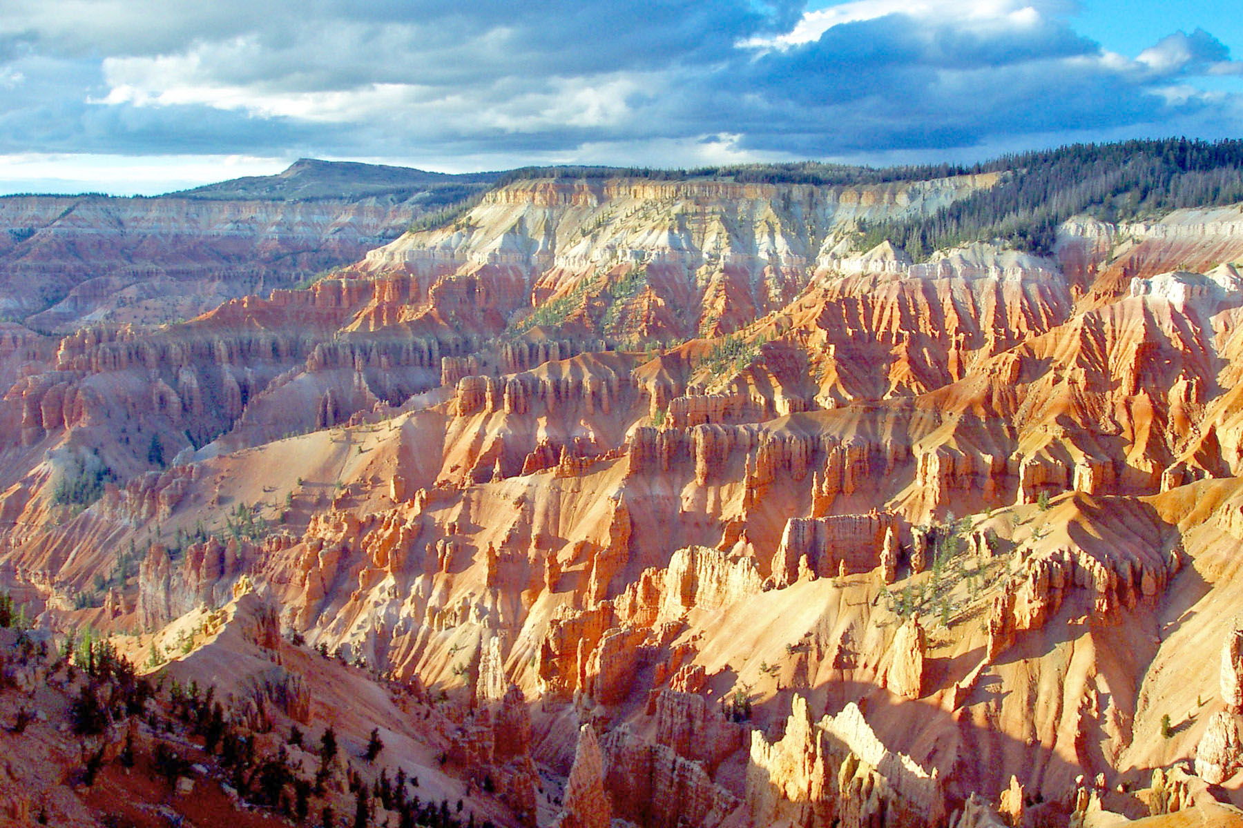
Crowning the Grand Staircase, Cedar Breaks sits at over 10,000 feet and looks down into a half-mile deep geologic amphitheater. Come wander among timeless bristlecone pines, stand in lush meadows of w...

13 mi from route ~32 min detour $10 near mile 59.9
Danger: State Route 148 Closed Through Cedar Breaks National Monument
View on nps.gov
Zion National Park

Zion National Park

National Park

Follow the paths where people have walked for thousands of years. Gaze up at massive sandstone cliffs of cream, pink, and red that soar into a brilliant blue sky. Experience the tall, stretching walls...

14 mi from route ~35 min detour $35 near mile 25.7
View on nps.gov
Timpanogos Cave National Monument

Timpanogos Cave National Monument

National Monument

The visitor center, caves, and cave tours have not yet opened for the 2026 season. Hike your way past stunning vistas to explore a hidden underground world. Taste the thrill of caving as you twist and...

27 mi from route ~66 min detour $12 near mile 248.2
View on nps.gov

Park data from the National Park Service API. Alerts update every 2 hours.

Fuel & Cost

Regular Gas

$39.33 one way

$78.66 round trip

$4.03/gal 25.4 MPG avg 87 kg CO2
Fuel Type $/gal One Way Round Trip
midgrade $4.22 $41.23 $82.45
premium $4.53 $44.28 $88.55
diesel $5.61 $54.80 $109.60

No toll roads detected on this route.

Estimated Trip Cost (one way, 1 person)

Fuel

$39

Meals

$25–$50

Total

$64–$89

Rough estimate based on US averages. Hotel $80–$140/night, meals $25–$50/day.

Estimated CO2 emission: 86.8 kg one way. Prices: EIA weekly data, 2026-04-13.

Driving Electric?

About $26 in charging · 0 stops · 67% less CO2

Vehicle Type kWh Stops DC Fast Home Charge
Average EV 74.5 0 $26.06 $11.91
Efficient EV 62.1 0 $21.72 $9.93
EV Truck/SUV 99.3 1 $34.75 $15.88

Gas CO2

87 kg

EV CO2

29 kg (67% less)

Plan for 0 charging stops, roughly every 270 miles. Allow 25-40 minutes per stop at a DC fast charger.

DC fast charging avg $0.35/kWh. Home charging avg $0.16/kWh. US grid CO2: 0.39 kg/kWh.

Travel Intel

Current conditions at both ends of the drive.

Forecast as of Apr 15, 2026

Origin

Saint George, UT

Afternoon in Saint George on Thursday

Local time

2:42 PM

MDT

Current temp

79°F

Unavailable

Live forecast

Destination

West Mountain, UT

Afternoon in West Mountain on Thursday

Local time

2:42 PM

MDT

Current temp

39°F

Unavailable

Live forecast

36°F

Beaver, UT

124 mi in

Seasonal Notes

Summer travel usually means heavier construction, hotter rest stops, and busier weekend traffic around major cities.

Winter travel shortens daylight, so a route that looks manageable on paper can feel much longer after dark.

Holiday weekends tend to make both departure and arrival windows slower than the raw route time suggests.

Time zone

Same local time

Origin and destination are on the same clock, so arrival timing is easier to judge at a glance.

Temperature spread

40 degrees cooler at arrival

A meaningful temperature swing is a good cue to rethink layers, water, and how soon you want to arrive.

Road read

4h 8m on the road

An early start around 7-8 AM gets you there with plenty of daylight left.

Weather data from the National Weather Service. Conditions may change; check closer to your travel date.

Frequently Asked Questions

The drive from Saint George, UT to West Mountain, UT covers 248.2 miles and takes about 4h 8m without stops. Add 15-30 minutes for a fuel or rest stop on longer drives.
The main roads are Veterans Memorial Highway, 9600 South, Saint George Boulevard. Expect a mix of highway and local road driving.
This is a comfortable same-day trip.
The midpoint is about 124.1 miles from Saint George, UT. Look for rest areas, gas stations, or food options near the halfway mark.
At current regular gas prices, expect to spend about $39.33 one way. This estimate uses 25.4 MPG — your actual cost will vary with your vehicle's fuel efficiency and current gas prices.
An early start around 7-8 AM gets you there with plenty of daylight left. A late afternoon start means arriving after dark. Morning is better.
Plan about 1 meaningful break for fuel, food, or rest. Plan on a short reset every 3 to 4 hours to stay fresh behind the wheel.
This is a straightforward 4h 8m drive. You will face about 12 decision points, but nothing that requires special attention if you follow navigation.
The main spots that need attention: at 0.1 miles (100 West): Navigation decision point; at 0.2 miles (200 South): Navigation decision point; at 0.5 miles (Main Street): Roundabout - know your exit number before entering.
The route from Saint George, UT to West Mountain, UT does not surface many named destination signs beyond the main corridor.
Yes. Nearby national parks include Cedar Breaks National Monument, Zion National Park and Timpanogos Cave National Monument.

Was this helpful?

Thanks for your feedback!

Your tip has been submitted. Thanks!

/500

Explore More

Return Trip

West Mountain, UT to Saint George, UT

Plan the drive back the other way.

248 mi 4h 7m

Explore more options from Saint George, UT or browse trips ending in West Mountain, UT.

Looking for more statewide routes? Browse UT road trips.

Explore maps for Saint George, UT or West Mountain, UT on MapSof.net.